Southworth Burial Mound
Take Myddleton Lane (the ‘Eastern avenue’ off the Winwick mound) out of Winwick towards Culcheth and it will lead down the ley line towards Croft where it becomes Southworth Lane as it passes the ancient Southworth Hall over the M6 motorway.
In the fields to the right Victorian Historical Journals from the Warrington Historical Society mention there may have been the burial mounds though these are now lost being ploughed flat, and in the field to the left on the Newton side, between the motorway and Southworth Hall itself, was sited a significant burial mound, this site had been observed and recorded for many years, and previously a bronze `palstave’ type axe was recovered from the area – but previously written or found locally could have prepared the archaeologists for what followed, when the site was fully excavated.
A Pagen Site – In use for over 1500 Years
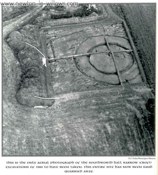
In 1980 a rescue archaeological unit from Liverpool University moved into the field to dig a known barrow that was threatened by sand quarrying, they unearthed a surprising set of results which had remained hidden in the soil of ages.
While excavating the site, It became quickly apparent that the archaeologists had unearthed a very ancient burial complex, built in three obvious phases, followed by a pre-conquest (pre-Norman) cemetery. I will deal with their discoveries in carbon 14 date order, remembering that most dates this method gives are plus or minus 80 years either way.
1. The Pit
The earliest feature detected at the site was an enigmatic and detached pit 6ft 4ins by 4ft 9ins by lft deep (2m x 1.5m x 300mm) filled with burnt cobblestones and charcoal dating back as far as 2140 BC. Stranger was the fact that the stones had not been burnt in the pit but brought from somewhere else and buried there!
One broken Bronze Age urn was recovered from this pit but no bones to indicate a burial. No solution for the presence or use of this pit has yet been forthcoming. It is a complete mystery! 51 feet (16m) to the south the next set of features were discovered.
2. The First Mound
In 1740 BC a mound 38ft (12m) in diameter was raised with a steep-sided, flat-bottomed ditch about 4ft 9ins (1.5m) wide and 2ft Bins (800mm) deep. Just off-centre the archaeologists discovered an oval pit l lft lins by 8ft lins (3.5m x 2.5m) and more than 3ft tins (1m) deep, flat bottomed and very steep-sided.
In the sand in the middle of this pit was a slot 2ft 4ins wide by 2ft 4ins deep (700mm x 700mm) and as long as the original pit. The report of the dig reads:
“The almost vertical sides of this inner slot make it difficult to accept that it had been dug into the unconsolidated fill of the larger pit without some form of lining. Alternatively, it may be that the larger pit had been backfilled around some structure. No evidence for lining or structure was found.”
Was this “slot” the site of a former standing stone or ‘needle stone’ erected during the Stone Age as a marker from the Winwick mound at A and then removed after a thousand years to accommodate a new breed of Bronze Age sacred site? The archaeologists also noted that the pit had a distinct north-east/south-west alignment.
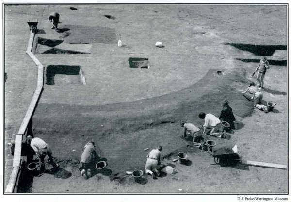
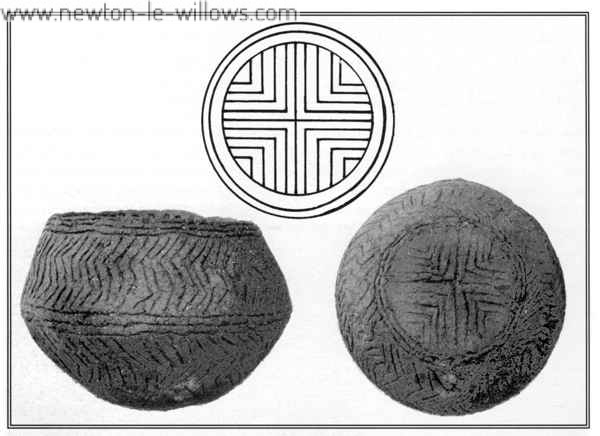
Three burials and another small pit were found from this period randomly dotted on the mound and ditch. One burial deserves a mention as the decorated pottery rim found represents the only discovery of a biconical urn of the early Bronze Age in Cheshire and is several centuries older than most other known examples, most of which are not decorated (which the Croft rim is).
Early date finds show that man developed in an unbroken chain from stone to bronze and to iron at Winwick and Croft. This early mound was levelled and the ditch filled in about 1600 BC to make way for another second structure – some form of wooden building!
3. The Shaman’s Sanctuary
A triple ring of stakes was driven into the levelled first mound in three concentric ovals measuring 4ft 9ins (1.5m inside ring), 12ft Sins (4m middle ring) and 20ft Tins (6.5m outer ring) and supporting a structure which only survived to be found by archaeologists as a mass of charcoal including some wattle and wider strips of wood like thin planks. The standing stone, if it existed, would have been removed by this point as the new wooden stakes cut into the now empty and filled-in central pit.
Was this an early Bronze Age religious ‘church’ of some kind, a sort of ‘Shaman’s Sanctuary’ like those still constructed by the American Plains Indians? Was it an observatory like Woodhenge near Avebury, Wiltshire (with a roof but open walls), where the ancients spent long nights of star-gazing and debate? It remains as another Croft mystery.
To add to this the wooden structure was mysteriously burnt down in about 1520 BC before construction of the second mound.
4. The Second Mound
The second mound (third structure) was a massive 76ft wide (24m) and more than 8ft (2.5m) high, roughly sited over the first mound and having a ditch 3ft 2ins wide by 3ft 10ins deep (1m x 1.2m). So large was this mound that the turf used to build it would have had to be brought in from the surrounding area.
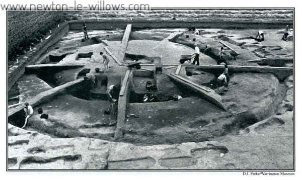
Nine, possibly ten, burials and a small bone knife hilt (`pommer) were found in this mound. There were two with urns, two with small accessory vessels, one with both and five with neither – but mysteriously none of these occupied the centre of the mound and all were inserted into the mound after its construction was completed.
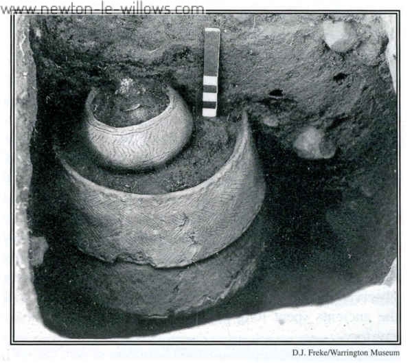
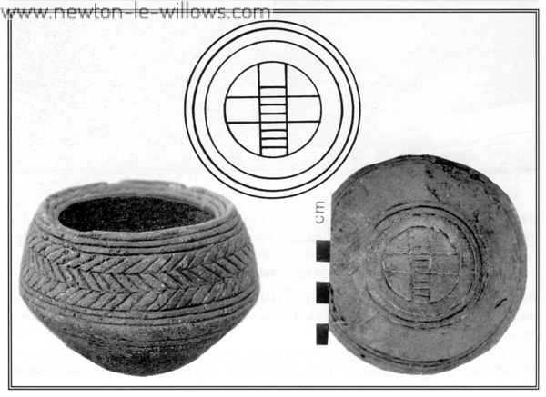
The burial with both an urn and an accessory vessel deserves a mention as the vessel had been buried at a later date to the urn but placed exactly over the middle of the older upright collared urn. The chevron markings on both are so similar that they suggest some direct relationship between both burials, the first of which must have been marked on the surface in order to be relocated. Was this father and son, husband and wife, human and sacrifice? We may never know. This burial is quite unique and dates to about 1440 BC (as do the others in mound two) and the use of the wheel-cross motif on the base of both accessory vessels is worthy of note for its age although the ancient significance is lost. (See photos P. 54)
The pattern of burials found in the second mound also suggests a plan to their location possibly relating to alignments. I will quote the final summary from the report published in the Journal Of The Chester Archaeological Society, Volume 70 for 1987-88 written by D.J. Freke and R. Holgate:
“Seven of the surviving cremations fall into two groups opposite one another, joined by the axis of the first phase central pit. This axis, if it is intentional, is the more remarkable because it indicates the persistence of an alignment from the earliest constructional period, when the central pit was dug, filled in and covered with a sand mound, through to the latest detectable Bronze Age use of the site after another mound had been erected over the top of the first.
“If this alignment did persist for c.300 years it suggests that some sort of long-term marker in the environment was being used. No obvious marker, such as a skyline notch, exists now in the landscape. No search has been made for a celestial alignment, which would be in the region of 45 degrees east of north.”
The account continues, “A possible secondary alignment, comprising the four other cremations and all five Bronze Age pits, exists at right-angles to the first. Only two of the north-east – south-west burials are without a pot, whereas only one of the four north-west -south-east burials has an accompanying pot, the crudest of the collection.
“If the two alignments are accepted, then it seems reasonable to consider the northeast – south-west one as the principal one on the grounds of the pit axis, the greater number of burials, and the number of pots accompanying them.”
As a final note to finds made in the mounds, most surviving bone fragments were adult with some identifiable as male but the acid soil had destroyed almost all traces of bones over the whole site. Many flint implements were found in the area but, whilst the arrow heads were clearly Bronze Age, there was no evidence that the rest were related to either of the mounds although Stone Age man had certainly been active in the area.
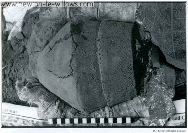
D.Longley in Prehistoric Sites In Cheshire, published in 1979, mentions an urn found at Southworth which may relate to this site or the “eastern barrow” mentioned in 1860 by Dr.Kendrick – but the urn has now been lost and no other details are available.
A Celtic savred Site – In use for over 1000 yrs
For the next two thousand years between 1400 BC and 600 AD, the development of the area can only be surmised as that dark ‘Celtic’ silence slips into the historic record once again.
It is known that burials began again on the site in the form of normal graves (not Bronze Age Urn cremations) at some point during this period, and the archaeologists
 |
 |
uncovered at least 819 of these burials in the trench surrounding the mounds, cut into the soft sandstone. It also appeared that burials took place actually on the mound which would increase this number to over 1200 and burials also stretched away across the field in all directions to as many as 2-3000 graves.At the time of the excavation some graves were found that could have been as late as the reformation period when Catholics were afforded shelter at Southworth.
No cemetery boundary was ever found and the enigmatic alignment from the original mound-pit continued into this period with most graves pointing 45 degrees west of north. Although two phases of burial were common over most of the site, a strangely high concentration of graves also seemed to have gathered in the vicinity of the original stone-filled pit from 2140 BC, with as many as four indistinguishable phases of burial crowded into a blur. Why? No one knows.
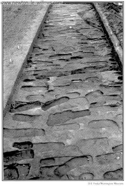
The site showed no clue to the position of a chapel, boundary or footpath but the fact that the burials show some degree of planning might show a date of Roman or later as such cemeteries as this are known in other areas of Roman and post-Roman Christian activity which did not succumb to early Anglo-Saxon settlement and the associated influences.
It has been surmised from a pattern of gaps in the burials that a wooden building 12ft 8ins wide x 25ft bins (4m x 8m) may have stood on the site but, like wooden coffins, only dirt discolouration remained.
A Christian Sacred Site – In use for over 1800 yrs
The archeological report suggests from the evidence that the cemetery remains are either
A. an early Christian one from the orientation of heads to the west, no grave goods and communal long-term burial rather than cremation, or
B. that it may be of much later Germanic origin based on the use of a burial mound
as the centre point and a single burial which had a stone either side of the head – a practice continued up to the late 11th century.
Of course the cemetery could span the whole of the Celtic period into modern times and there are no other indications at this time to support the ‘Germanic origin’ theory.
There was certainly a chapel in the township of Southworth in 1292 AD and the field in which the burials lie was recorded as ‘Further Chapel Flatt’ on a map as late as 1841, quite a coincidence if this had nothing to do with the cemetery. But still the greatest mystery remains, why did the pattern of the cemetery stay the same for 3500 years from the Pagan into to the Christian era and what do the structures represent?
As a last word I will quote again from the the Chester Archaeological Journal No 70:
“Though such evidence as it yields looks middle or even late Saxon, the Winwick (Southworth Hall) cemetery could well have spanned the whole Dark Age period. Viewed thus it provides crucial evidence of pre-Conquest activity in an area singularly lacking in British and Anglo-Saxon remains.”
Sadly, this whole site has now been utterly swept away by sand quarrying.
This text version is transcribed by Steven Dowd from book one, of the series of books. “Celtic Warrington and other mysteries” written by Mark Olley, the photographs are by D. J Freke / Warrington Museum. permission was obtained for use of the text and photos here at https://www.newton-le-willows.com, copyright is retained by Mark Olley

