Historical and antiquarian notes on Warrington and its Neighbourhood
By John Babson, Esq.
The object of the present communication will be to combine as well as I can the evidence from historical records, local traditions, and existing remains, so that each may throw light upon the other, and afford something like a continuous history of the district you have passed through this afternoon.
The earliest remains we have to notice are the Tumuli, of which we have two marked on the Ordnance Map, to the east, and a little to the north of Winwick Church. The further one has been opened, but nothing was found; the other is not correctly represented in the map, where it appears as if the lane went over it, but, in fact, the highest point is in the field, and it seems to have had two offshoots, one from its north-east side, which has apparently run across the lane, and been cut through, the other to the north-west. The centre Tumulus is from thirty to forty yards in circumference, and about eight feet above the level of the lane; it is most likely sepulchral. Castle Hill, in Newton, is probably of a later date, and I shall refer to it hereafter. Another, marked “Mound” on the Ordnance Map, is on the south-west side of Newton Common, it is on the highest bank of the valley of St. Helens’ Brook, more extensive than, though not so striking as the Castle Hill, and called Windmill Hill by the country people. A windmill no doubt, has stood upon it; but such was not the original purpose for which it was thrown up; and in the absence of evidence of any sort, conjecture would be useless.
Two instruments, apparently also of this period, have been found in the district, or very near it; one, (a double-headed chisel – shall I call it?) was found in Orford, near the boundary of Winwick parish. It is formed of flint, and intended to out with, but how it has been used, is not so easily understood, as there is no space or accommodation for a handle. It was found in the clay while making a drain. The other has been supposed to be a war club, and a formidable weapon it must have been at close quarters. It is formed of clink stone, is about 17 1/2 inches in length, and 8 or 9 inches in circumference at the centre, tapering a little towards the ends. It weighs 6 1/2 pounds, and was found on the left of the highway to Newton, on New Hey Farm, and not far from the track of the Roman Road you have examined to-day.
There is another unappropriated relic found at Haydock; a piece of coarse freestone has been rounded, and a hole drilled through it, the edges of the opening on both sides being bevelled off towards the centre. It was found some feet below the surface, when opening a new coalpit belonging to Messrs. Evans. Stones something like this, are used by rude nations to keep the threads steady in weaving, or it might be used to sink a net with. Perhaps we are too much in the habit of taking for granted, that instruments like these were always used as instruments of destruction or war. The stone club would answer every purpose of a modern mallet.
The next object in chronological order is the Roman Road, and though here we are at no loss for its origin or the time of its construction, there are several points of interest, and some that may be profitable in more extensive researches; for in all archa3ological inquiries, a well established fact is perhaps more valuable for its application in other places than for its original local bearing. This road, which is clearly of Roman construction, is formed as you have seen, not of pavement, but of a substructure of rude masses of sandstone built up together six or seven yards wide, and covered with a thick bed of gravel, while in some places, the sod has been previously removed, and a layer of sand spread below. The depth of the road in the centre is between two and three feet, the stone foundation being about one-half. The rounded crest of the road is often plain enough, its course generally straight, and there can be little doubt, that the road at Haydock has been a direct continuation of that at Appleton, and that the whole has been formed by the same engineer. Now, as we know that the Romans had conquered the Brigantes and Cangii A.D., 60, and that Suetonius Paulinus attacked Anglesey in 61, it seems natural enough that either then, or soon after, when Julius Agricola advanced to the north, which he did from Wales in 78, the road was formed, or at least in a state of formation. A milestone was found on the line a little to the south of Lancaster, inscribed to the Emperor Julius Philippus, who reigned between 244 and 249; but this might be a reparation or renovation at a later period ; any way, the construction of the road mast have been between 50 and 249.
This road has been traced to the top of Orford Avenue, on the northern line to Warrington, and to the bank of the river Mersey, at Wilderspool, on the south. Between these two points, (a distance of about a mile, through the town of Warrington) no evident trace appears, and the common opinion was, that it went between the Mote Hill and the Church ; then by the bank of the river to the old ford at Latchford, and so round by the high ground to Wilderspool. A much nearer route, however, is by Orford Lane, the high ground on the west side of Fennel Street and Mersey Street, (a Roman coin of Marius was dug up last summer in Back Irlam Street, on this very line, and is now in the Warrington Museum), and across the river, by a ford just below the bridge. This ford consisting of a strong bed of gravel, may still be seen when the water is very low, but has been destroyed on the Warrington side, in improving the navigation of the river. It may then have taken the course of, and been buried under Wilderspool “causey,” and so joined the road at Wilderspool. I may say that both these statements are hypothetical. The road itself has been most effectually removed.
The fact, to which I shall now turn your attention, is the very perfect state of the road in some places compared with its utter destruction in others. Of course, he removal in the neighbourhood of towns is easily understood; and I think that in our investigations this day, a new and unexpected solution of the problem has been obtained at Haydock: you have seen the once-substantial and solidly-built road, crumbling away as it were, and becoming so mixed with the soil, as hardly to be distinguished from it. The soft sandstone has become thoroughly disintegrated, and we find instead of the large ashlers which once formed its basis, a few small and scattered pieces mixed with the gravel, which itself, in many places has been purposely removed.
We must now pass over many years of which we have neither visible remains, historical records, nor household traditions, to a period when we have all of these bearing upon the history of St. Oswald, King of the Northumbrians. Oswald assumed the crown in 634, and according to Beda, “brought under his dominion all the nations and provinces of Britain, which are divided into four languages, the Britons, the Pict’s, the Scots, and the English.”He had embraced Christianity, and was a zealous propagator of the faith, of which you will find numerous details in Beda’s Ecclesiastical History. He was, however, “killed in a great battle by the same pagan nation and pagan king of the Mercian’s, who had slain his predecessor Edwin, at a place called in the English tongue, Maserfield, in the 38th year of his age, on the 6th of August, in 642″ *Beda goes on to say, that in consequence of the miracles performed where he died, is many took up the very dust of the place where his body fell, and putting it into water, did very much good to their friends who were sick. This custom came so much into use, that the earth being carried away by degrees, there remained a hole as deep as the height of a man ;” and strange enough, this is the very state of St. Oswald’s well at this day. It is a hole about two feet in diameter, and apparently five or six feet deep, with a little water at the bottom, which has evidently drained from the higher ground, but the hole has not been walled round, and is simply an excavation of the soil.
We have, however, a different account in William of Malmesbury, + who says “that in the insurrection excited by Penda, King of the Mercian’s, his guards being put to flight, and himself actually carrying a forest of darts in his breast, could not be prevented by the pain of his wounds or the approach of death, from praying for the souls of his faithful companions.” The Saxon Chronicle, year 042, says, “This year, Oswald, King of the Northumbrians was slain by Penda, and the Southumbrian’s, at Maserfeld, on the nones of August, and his body was buried at Bardney.”
Florence of Worcester, (anno 642), uses the expression ” commisso gravi praelio in loco Maserfelduuncupato.” The Annales Cambriae under 644, have ” the battle (bellum) of Cocboy, in which Oswald, King of the Northmeu, and Eoba, King of the Mercians were slain.” While the history of Nennius, which is also derived from ancient British sources, tells us, that “Penda, son of Pybba, reigned ten years ; he first separated the kingdom of Mercia from that of the Northmen, and slew by treachery, Ouna, King of the East Anglians, and St. Oswald, King of the Northmen,. he fought the battle of Cocbey, in which fell Eoua, son of Pippa, his brother, King of the Mercian’s, and he gained the victory by diabolical agency. he was not baptized, and never believed in God.” Geoffrey, of Monmouth, has a totally different detail, though the actors are pretty much the same.
It would be utterly hopeless to reconcile those varying statements, and I should prefer William of Malmesbury, as agreeing best with the traditions of the neighbourhood; according to these, the king lived at Woodshead, where he was set upon by his enemies; he was mortally wounded, and attempting to escape, fell on the slope of the bill. The account I heard when a boy was, that his bowels gushed out, and that he kept them in his hands till he fell.
From Beda’s account it follows, that the place was at a distance from any town—and no church was erected on the spot—there was also a frequented road running past it ; now all these marks belong to the present locality, and we may proceed to show that the church of Maserfield, or Mackerfield was in the time of Oswald, at Winwick.
Roger of Poictou, according to the Testa de Neville, gave to the Canons of St. Oswald, at Nostell, in Yorkshire, the church of Winwick, with two carucates of land. In Dugdale’s Monasticum, we find that the Priory of Nostell was formed on an old foundation, in the time of William Rufus, and that at the beginning of the reign of Henry I., Stephen, Earl of Moreton, and his chaplain, Roger de Limesey, gave to this priory the church of St. Oswald, in Macrefield, which grant was confirmed by Henry II. • In Domesday Book we are told there were five hides in Newton hundred ; of these one was in domain. The church of the manor itself had one carucate of land, and St. Oswald of the vill itself had two carucates of land, free from all claims: thus the church of the manor was distinct from the church of the vill. The King appears in Saxon times to have held all the land except five carucates. In another of the public records – the Proceedings de Quo Warranto, in the time of Edward I – Richard de Waleton claims to be bailiff of the Wapentakes of Derbyshire and Makerfield, by gift of William, Earl of Bulon and Morton, to his ancestor Walter.
That these different documents referred to the same place is certain. The hundred of Newton was the Wapentake of Makerfield, which probably was the name of the royal domain, and so furnished the title to the district now included in the fee of Makerfield. After the death of Oswald, the royal residence seems to have been transferred to another site, to which naturally enough the name of Newton – the New Town or Vill – has given, and this again was transferred to the Hundred. To this period I would refer the formation of the Castle Hill, which might have formed a part of the in-closure of the King’s residence. I am not aware that the Hundred of Newton occurs anywhere except in Domesday Book – both it and Warrington hundred merged in West Derby – but the hundred of Makerfield is still extant in a fee of the same name.
The Saxon Kings, who had no civil list, lived upon each of their manors in succession, as long as it would support them ; and the piety of Oswald and zeal of St. Aldan would soon found churches all over his kingdom – of course the immediate neighbourhood of the royal manor would not be left destitute of a church – and we know that the division of parishes took place at the introduction of Christianity, or at any rate was confirmed then, and the parish church became the spiritual centre of the district. This is rather oddly confirmed by the tradition of the Pig, which is sculptured in low relief on the steeple. The tradition is, that the church was to have been built near the spot where the King was killed, but the stones and materials which were collected there from day to day, were carefully removed during the night. Upon a watch being set, it was found that a pig was the industrious agent of removal, and its natural squeak directed the founders to the present site of Winwick. The reason why the church was not built at Woodshead was clearly that the church was already at Winwick. This tradition, at least in its present form, is of late origin. The pig is the attendant on St. Anthony, who occupied the niche beside it, and the steeple itself is of the 14th century, and no part of the original structure. It is possible, indeed, that St. Anthony interested himself in the business, and the people recognised him in his pig – (or he may have been mistaken for St. Aidan, an intimate friend of St. Oswald’s, though not so well known) – and placed his statue in rei perpetuam memoriam in the previous building ; but it is not so easy to see how the saint should have been so utterly forgotten, as before the Reformation he must have been a very familiar and well known object to the people. Is it possible that the tradition can have arisen since the 16th century and the downfall of the saint from his niche?
The ornamentation of the transverse limb of the stone cross, now placed at the east end of the church, will put you in mind of the Runic cross discovered in Lancaster, and now in the museum at Manchester. It is of great interest though a mere fragment. Is it a preaching cross erected where Paulinus had stood and taught the doctrines of a purer faith to the inhabitants of Makerfield, with their King amongst the audience? or a sepulchral one to mark the tomb of some forgotten Saxon Saint or Chief? or is it a churchyard cross given by one of the later Saxon Kings, or by the Prior of Nostel when he took possession of the church and fat lands of the rectory in the time of Henry I? Its dimensions must have been magnificent, far larger than the majority of such crosses, the wheel of which is seldom more than a foot in diameter. The interlaced ornament, though not peculiar to, was usual among the Saxons, and to this period I should refer our specimen, though instances of a later date occur in Ireland.
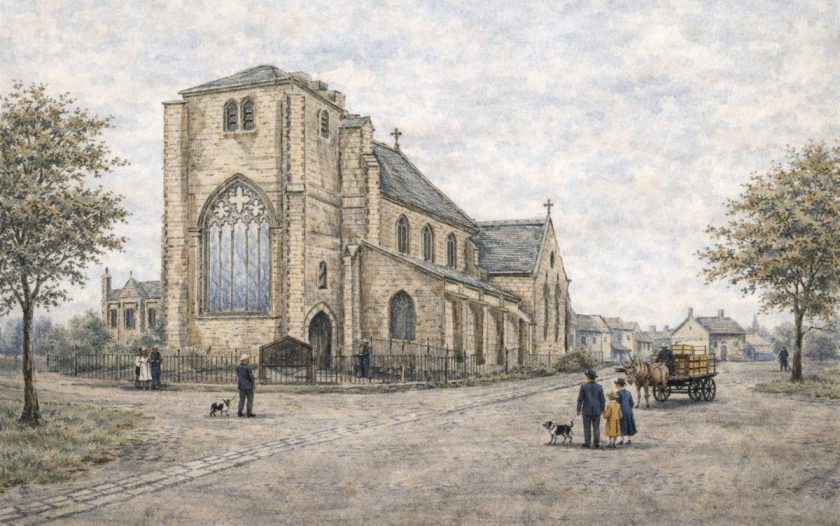
I shall not keep you long in describing the church. It consists of a nave with clerestory, side aisles, each terminated by a private chapel – chancel, which has just been rebuilt – porch on the south, now converted into a lumber room – and western tower with a plain spire. The tower is of the flowing decorated period, has a western doorway, a window with a niche on each side empty – the pig looking to the niche on the right – a door with a flat trefoil like top inside opens on the stairs – the shafts on the south side of the nave are clustered of four round pillars, the capitals with beaded mouldings and a necking below, and supporting pointed arches, consisting of two square orders, the edges being canted off. The shafts on the north side are octagon, formed of a hollow and a round with fillets, the capitals with fleurs de-lis, or the stalk foliage, cut in the stone, and the bases with a mitred head at the corners – in fact the bases of all the columns are peculiar, and the church would gain a good deal if the present pews were removed and the whole work shewn. The arch mouldings over these shafts are the same as those of the western entrance, and two engaged shafts of the decorated period form the entrance to the chancel. There are two shafts with square abaci at the western end of the Legh chapel, which contains the brass of Perkin Legh and his wife, and two later marble monuments of the same family. The Gerard chapel on the opposite side is enclosed by a screen of the date 1471, and contains a brass of Piers Gerard, Esq., son and heir of Sir Thomas Gerard, who died 1492. The side aisles and clerestory may have been built by Thomas Johnson, whose name appears in the inscription which is placed beneath the battlements on the outside.
The changes that have been made in the church, however, are so great, and the records connected with its reparation being res non inventor, I shall take up your time no longer with attempting to distinguish the generic features, but pass on to the inscription just alluded to:—
Northanhumbrorum &eras rex, nuncque polorum
Regna tones; prato prius; Marcelde vocato
Poscimus hinc a to nostri memor esto beats
Anno milleno quingentenoque triceno
Sclater post Cristum murum renovaverit istum
Henricus Johnson curatus, erat annul hic tunc.”
In connexion with the present subject, we find in the Fifth Report of the Deputy Keeper of the Public Records, p. 66, App. 2. Calendar of Letters, &c., in the Wakefield Tower, the following – “494, Roger, Bishop of Lichfield and Coventry, to the King – praying aid against certain persons who had seized the churches of Leech’ (Leigh pronounced still with the guttural] Bury and Wynwyke, 29 Jan. 1264.”
A few words on the “Bloody Stone” which is placed at the edge of the footpath opposite Park Barns, and I have done. The tradition is, that some great person was killed there, and the marks of the supposed blood-stains are still visible after a shower. A more particular account says, that it was a Scotch lady who was beheaded by Oliver Cromwell after Red Bank fight – which took place here – and a field on the east side of the road is said to have derived its name of Gallows Croft, at the same time, from a number of soldiers having been hanged there by the same redoubtable commander. Cromwell, however, following a beaten enemy as hard as he could, and when every hour was precious, would hardly linger on his way to behead women or hang his prisoners. The Gallows Croft is at the verge of the township, and may have been the site of the original baronial gallows, when the Baron of Mackerfield rejoiced in that important addition to his state. Mr. Beamont first suggested that the Bloody Stone, which certainly was in Newton Park, might be the place where the Welsh Knight, who had usurped the Castle of Haigh and the Lady Mabel was killed by the real Lord, Sir William Bradshaigh on his return from the Holy Land. This event, if it took place at all, would be in the reign of Edward I., and about the time when the church tower was built.
I have now gone through the facts and traditions connected with the history of Win-wick to the 16th century. The township is decreasing in population, but whether it and Newton were ever the great towns which popular tradition would make them, may be doubted. They were certainly Royal Manors before the conquest, and Culcheth (in the parish of Winwick) has been assigned by high authority, as the site of many synods of the Anglo-Saxon Church. Many charters are dated from Caelchyth, or Celichyth – and the place is called Kilsha by the country people. We have also one of the farm houses moated round, and called the “Old Abbey ;” but when or why this name was given, is utterly unknown It seems to point to some ecclesiastical building of remote antiquity.
This was transcribed from out of copyright original material dated 1875 by Steven Dowd for use at the Newton-le-Willows website ©2007