THE ROMAN ROAD FROM NEWTON BROOK TO THE SOUTH OF THE PARISH CHURCH, WARRINGTON.
An account of the investigation carried through by G. A. Dunlop, F.S.A., and Colonel B. Fairclough, C.M.G., D .S .0.
[Reference Maps, Ordnance Survey, 6 inches to 1 mile ; Lancashire, sheet CVIII, NE., 1928 ; Lancashire, sheet CVIII, SE., 1929 ; Lancashire, sheet CIX, SW., and Cheshire, Part sheet XVI, 1908 ; Lancashire, sheet CXVI, NW. Cheshire, Part sheets XVI and XVII, 1929.]
INTRODUCTION.
THE Ordnance Survey Maps, Lancashire, sheet CVIII, NE., and Lancashire, sheet CVIII, SE., both 6-inch, show the Roman Road coming south, from the direction of Newton-le-Willows, Lancashire, over land which for many years was pure morass. Considerable areas are still liable to floods, despite drainage and cultivation.
As the 25-foot and 50-foot contours rise to the east from the edge of this low-lying land, all the way from Newton Brook to Longford, and knowing the Roman engineers were too experienced to waste such a natural advantage, the investigators surmised that the road might be found along the ridge of the higher ground, and not as plotted on the Ordnance Map
The subject had already received some attention. In the first half of the nineteenth century a number of local gentlemen interested themselves in the location of the Roman road in the neighbourhood. The Rev. Edmund Gibson, of Ashton-in-Makerfield, Dr. John Robson, and Mr. William Beamont, all wrote papers on their investigations. A most important contribution is the chapter written by the Rev. E. Gibson, in Baines’s History of Lancashire,(1) on Roman Roads. Mr. J. Thompson Watkins (2) summarises all the previous writers’ contributions to the subject.
Before beginning our investigations we carefully studied the evidence brought forward by these earlier investigators, and wish to acknowledge much help from it. If we found cause to differ from their conclusions at times, it was because every effort was made to verify the facts with more modern methods.
Nothing was taken for granted and every bit of the road identified by us was proved by actual digging. Where we relied on the probe only is distinctly stated.
PHASE I.
(Figs. 1 to 15 inclusive.)
 Fig.1 |
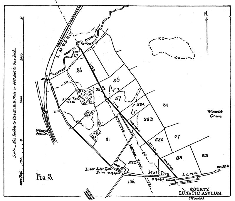 Fig.2 |
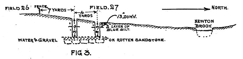 Fig.3 |
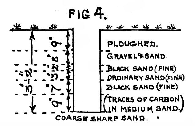 Fig.4 |
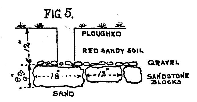 Fig.5 |
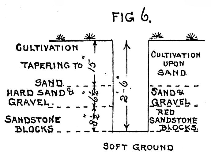 Fig.6 |
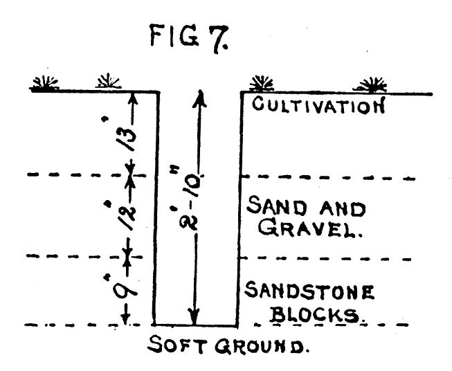 Fig.7 |
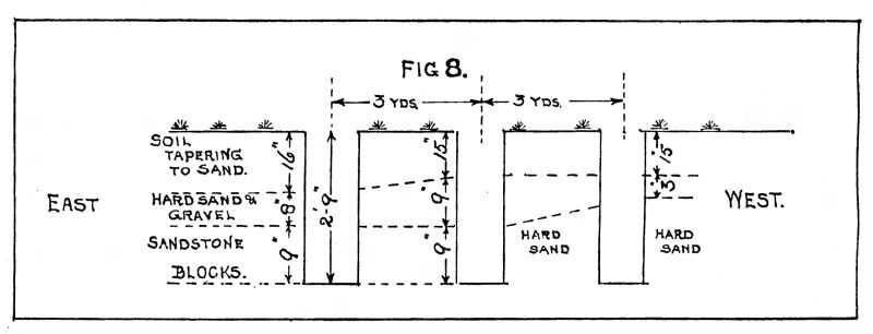 Fig.8 |
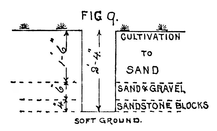 Fig.9 |
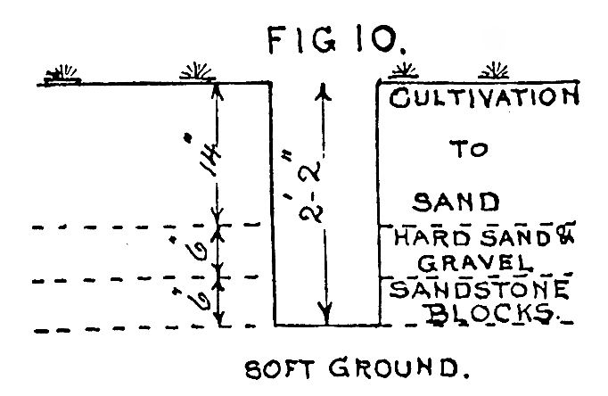 Fig.10 |
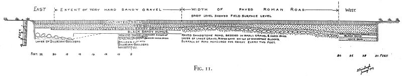 Fig.11 |
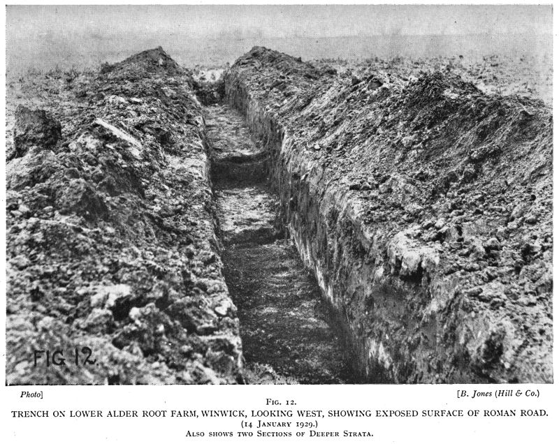 Fig.12 |
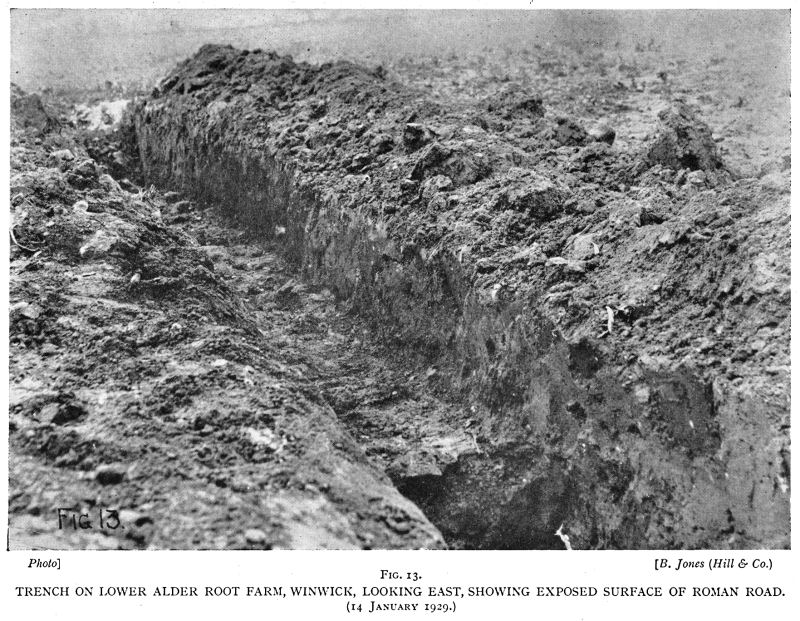 Fig.13 |
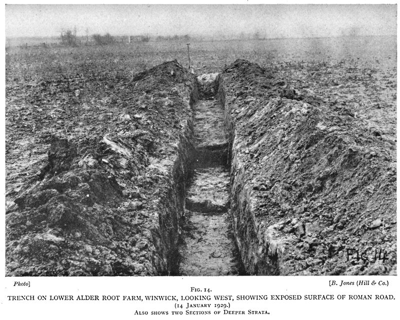 Fig.14 |
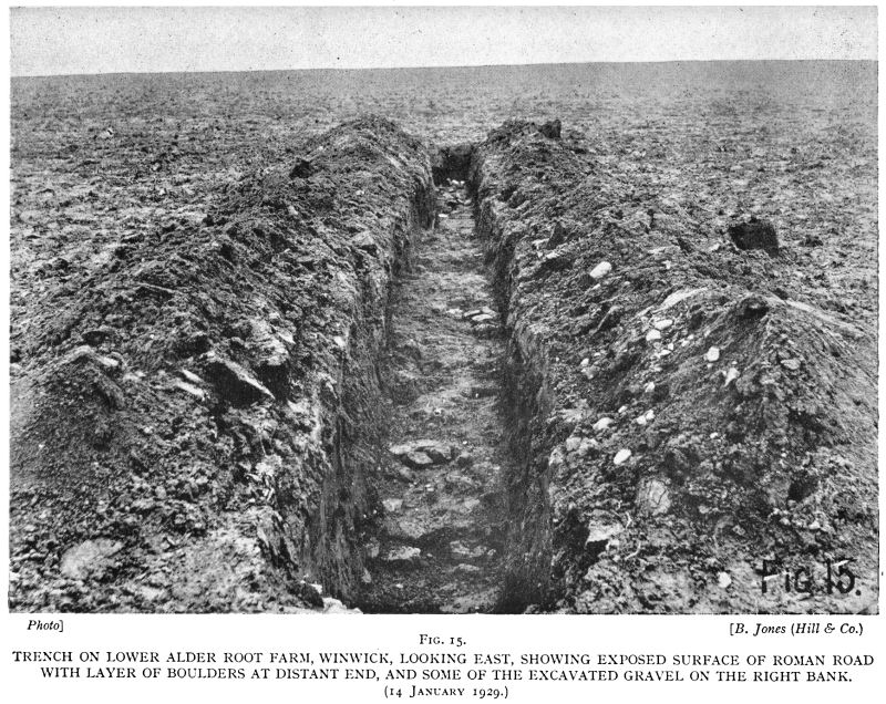 Fig.15 |
In September, 1928, we made a start at Hulme (see Map, Fig. 1), by probing carefully 3 feet down, in fields 370, 360, and 425A, but were unable to touch anything hard. A wider cast was made by probing fields 398, 372 and 397 without a ” find.” A very careful probing survey was made in field 396. A clay pit existed in the past at the east end of this field, where field 376 adjoins. The approach road, made of large sandstone blocks, was found leading from field 152 ; the south-east end in the clay pit was found to die away to nothing. Traces of sandstone were found in the hedge which divides field 152 into two parts ; just where the Roman Road site is shown on the Ordnance Map, Lancashire, Sheet CVIII, SE., 6-inch, 1929 edition, underneath the sandstone, modern brick was found. Holes dug on the Ordnance line failed to disclose anything but local subsoil, white sand, or boulder clay with accompanying pebbles. Probing at about 6-foot intervals, we were unable to obtain any clue to suggest the Roman Road ever passed through fields 370, 372, 397, 396, 152, Mill Lane to Delph Lane. For obvious reasons we could not survey the line between Delph Lane and Hollins Lane.
Mr. Bell, the farmer at Lower Alder Root Farm, took us to field 58B, and showed where he turned up gravel and sandstone blocks with the plough. On digging down, a paved surface was found, with gravel on the top of it. A surface gravel band gave a general line north-west. The probe and spade proved the paving followed the line of surface gravel through fields 58A and 37 to a point which intersects with the Ordnance line of the Roman Road. Fields 81 and 58D were probed and holes dug to find traces on the Ordnance line ; not the slightest trace of the Road could be found, not even a surface gravel indication. It is suggested that the contour lines should be observed, and also the Bench marks in Hollins Lane (Fig. 2, Map).
We went after this to Newton Brook. After locating exactly on the ground the Ordnance ” Roman Road ” line, we probed and dug two holes, 7 and 11 yards north of the southern fence of field 27, and obtained the sections shown on Fig. 3.
These holes were dug on a natural-looking slight causeway which slopes down to the north from field 26 towards the bend in the course of Newton Brook, which turns south at this point. The banks of the Brook at this point are very suitable for bridging, but at this date may not be exactly as it was in Roman times. No trace of bridge or ford was to be seen. From the above-mentioned holes, looking south, the ground rises slightly and a gravel band could easily be seen in the corn stubble in the northern half of field 26. The southern half of field 26 having been recently ploughed, the gravel line was very marked. This proved the Ordnance line of the Road to be correct here. A hole dug about 87 yards north of the fence between fields 26 and 36 about the centre of the gravel line gave the following section (Fig. 4).
Three holes were dug on a line east and west, 6 feet north of the fence between fields 36 and 37, and in each hole sandstone blocks were found with about one inch of gravel on the top of the blocks—stones 12 inches down from the surface of field. Two holes were probed which also gave sandstone 12 inches down. The width across the proved sandstone was 14 feet. The position of the centre of this 14-foot paving was defined by prolonging the line of the westerly fence of the farm road giving access to field 37, to cut the fence between fields 36 and 37, and from that point of intersection to the centre of the paving was 33 feet towards the west. A line from the holes dug by Newton Brook in field 27 to the centre of the last holes dug in field 36, runs along a well-defined causeway, and follows the centre of a band of gravel which is about 24 yards wide, the pebbles along the centre being as thick as 4 inches apart. In the remainder of the field gravel stones are not very common.
On probing at 12 yards south of the fence dividing field 36 from 37, it was evident that the road here was changing direction more to the east, sandstone blocks being found 10 inches down from the surface, with plenty of gravel and sand on the top. At 24 yards south from the above fence, the change of direction was more marked towards the east, sandstone blocks, gravel and sand about 12 inches down. Sandstone and gravel was found also in two more holes dug farther south.
The ditch at the west side of the farm road at the junction of fields 37, 81, and 58 had been cleaned out recently, and on the north bank there was plenty of gravel over a length of about 3 yards. On sighting back northwest all the last four trial holes ran in a line from the eastern gatepost of the farm road.
The next hole was dug 39 yards east of the bend in the farm road from Lower Alder Root Farm, on the high ground in field 58B : at 12 inches down hard red sandstone paving was found, with gravel layer, irregular in thickness, on the top. Sandstone, irregular in shape, ran up to 18 inches in diameter and 8 inches to 9 inches thick (see Fig. 5).
Gravel on the surface can easily be traced along a band about 12 yards wide, running north-west. The centre line of the gravel band seems to run between two small field bridges at the most northerly end of the farm lane before mentioned. The easterly of the two bridges between fields 58A and 37 is made of squared sandstone forming a flat top to irregularly shaped sandstone sides of the arch over the small field ditch. The sandstone under the Roman Road in field 58A and the northern part of 58B is very rotten and perished as the ground is low and wet. The southern half of field 58B has the sandstone foundation in very hard and good condition.
In field 58c we dug five holes equally spaced in a line east and west over a distance of 12 yards. The two outer holes showed traces of gravel, but the three inside holes all showed gravel on sandstone which was soft and badly perished, being easily scraped away with the spade. Below the sandstone was soft ground (see Fig. 6).
Compass bearings on two distant and one near point gave the position of the centre hole of the five as being 895 feet east of north end of Lower Alder Root Farmhouse, and 815 feet north-west of the north end of Winwick Hall Lodge
A hole, on a prolongation of the line of the previous holes, dug 73 yards north of the north-west rounded corner of field 88, gave a section as per Fig. 7.
Three holes dug on a line east and west at 11 yards due north of the centre of the bend of the ditch running round the north-west corner of field 88 gave the section as per Fig. 8.
A hole dug 15 yards farther west had a soft bottom at 3 feet down and nothing hard was touched.
Two holes dug on a line east and west, 7 yards south of the north-west corner of field 88, gave a section as follows (Fig. 9).
Three holes dug on an east and west line about half-way down field 88, and two holes probed as well, over a distance of 6 yards wide, gave hard bottom at 2 feet and also at 20 inches. Soft ground beyond the 6-yard area probed and dug. Section of holes as Fig. 10. A hole dug about 3o yards farther south-east down field 88 gave a section with sandstone blocks 2 inches thick at 12 inches down from the surface with a thin layer of gravelly sand on the top. Soft ground below the sandstone blocks.
A line sighted from Fig. 8 hole through holes Figs. 9 and 10 through the above hole, cuts Hollins Lane 97 feet east of the eastern gatepost of Winwick Hall Lodge entrance-gate. This point is 280 yards east of the place where the Ordnance Map, 6-inch, shows the site of the Roman Road to cross Hollins Lane. Probing and digging just a few yards north of Hollins Lane in field 58D, where the Ordnance Map shows the line of the Roman Road crossing Hollins Lane, failed to disclose any sign of the Roman Road. We were unable to trace any surface signs of gravel or slight banking either, field 58D being absolutely bare of vegetation at its southerly side.
On January 5, 1929, we cut a trench a yard wide, roughly east and west, through the two holes shown in section by Fig. 10, and exposed the surface of the Roman Road over its whole breadth. The Road is composed of sandstone blocks roughly 8 inches in diameter and about 41/2 inches thick. These blocks seem to be embedded in a very thin layer of small-stoned gravel and sand. The inequalities of the surface of the sandstone blocks were filled with larger-stoned gravel (up to 2 inches).
Gravel is scattered largely in the soil either side of the line of the road, which may account for the sandstone only having 2 inches of gravel and sand on it. A week later the outer flanks of the road were investigated by trenching. On the east side of the road there is a layer of hard sandy gravel, maximum-sized stones of which were 3″ x 1 1/2″ x 1″ oval. This layer extends 20 feet 6 inches eastwards from the east side of the paved road. The gravel layer is 4 inches thick nearest the road and 2 inches thick at the east end, where it suddenly dies out. The top of this layer appears as if it was continuous with the original layer of gravel on the sandstone blocks forming the road foundation. The Road itself is 14 inches below ground at the east side, 18 inches at the centre, and 20 inches at the west side. No signs of a ditch at either side of the road. On the west side of the road, the gravel was traced 6 feet to the west of the road, maintaining its height-level with the top of the sandstone gravel covering. Under the east end of the gravel band at 2 feet 1 inches down was found a layer about 6 feet 6 inches long of Westmorland bluish Silurian boulders about 8 inches diameter and less, embedded in whitish sand. About 8 feet east from the east side of the road, at 2 feet 9 inches, was found boulder clay speckled with coal fragments with Silurian pebbles embedded in the top few inches underlying the white sand. At the west side of the road, under the white sand was found wet, dark, alluvial, gritty, sandy slurry. Attached is a scale drawing of the section of the road—looking south (Fig. II). Road 24 feet wide. Four photographs are shown ; one (Fig. 12) taken from the east end of the trench looking west along the trench ; another (Fig. 13) taken looking west, and showing the best ” close-up ” of the whole of the road width we could get ; another (Fig. 14) looking west, showing type of country as seen from the east end of the trench. (The gate shown leads from field 88 into Hollins Lane and is the opposite side of Hollins Lane to the Bench mark 46.7, the trench itself being about 6o feet O.D.) Another photograph shows the trench and road looking from west to east (Fig. 15). In digging the hole, shown at 8 feet east from O or base measuring point on Fig,.11 a sample of the ” black sandy humus ” and also of the ” white ” sand was taken and subjected to examination under the microscope, drawings were made of various objects seen, and over each drawing is placed some strokes which denote the number of specimens seen on the slides.
These drawings were referred to a marine biological expert, who assured us that the diatoms drawn were of brackish or salt-water habitat. The height of the site where they were found is about 6o feet O.D. The ground falls away gradually from this site, southwards with a little west in it, down the course of Mill Brook, into Sankey Brook and thence into the River Mersey. As the lowest O.D. level at which the road has been located by us is about 26 feet O.D. at a point south of Alder Lane just south of Longford Bridge, the possibility of the road being made to skirt a salty lagoon must be ruled out of the question. Other likely bearings on this point will be discussed later.
Another trial hole was dug just north of Hollins Lane and sandstone paving found, which proved the correctness of the Roman Road passing 97 feet east of the east gatepost of Winwick Hall Lodge. For ease of description we referred to the length of road just described from Newton Brook to Hollins Lane as Phase I. The most striking points which emerge from the investigation so far, are :
1. The failure to find any trace of the Roman Road in the position shown on the Ordnance Map, between Mill Lane, Mill Brook Bridge and field 37 north of Hollins Lane.
2. The actual line of the Road, when working southwards, varied from the Ordnance Line, eastwards, starting at a point just north of the hedge dividing fields 36 and 37.
3. The line of the Road is clearly marked along its path by a broad band of scattered gravel, most plentiful just over the road itself.
4. The Road is made of paved irregularly hewn sandstone of varying thickness. Coarse gravel is found as a surfacing material on top of the sandstone. Smaller gravel was used for bedding for the sandstone blocks. We were unable to trace signs of drainage ditches on the sides of the road, although we looked for them. Nearer Warrington, downward curved black bands at the edge of the Road were exposed in many holes dug. The sandstone blocks in field 37 were so perished they could easily be cut with the spade. They were nearly black in colour, but the blackness showed the shape of the stone when compared with the lighter-coloured partings between adjacent stones. The stone was not quite so perished in field 58A and northern part of 58B. The stone was of a hardish character in the southern part of 58b, 58c, and 88 (all but the extreme south of 88 just north of Hollins Lane, where the ground is much damper) ; and was similar in quality to that in the quarry at the north-east end of Delph Lane (see Fig. I, Map).
5. The road varies in width, being 14 feet wide in field 36, and 24 feet wide in field 88 (Fig. 2, Map). In field 26 the road seems to be made of gravel and sand (see Fig. 4).
6. Investigations as to the reason of the 24-foot width were made to see if this area might disclose any signs of there being a halting-place near by. The flat ground to the east of the Roman Road in field 58c looked promising. We probed over 2,000 feet at 6-foot intervals on this field and dug numerous holes, but could not find any definite signs, although solid sandstone rock is to be found from 1 foot 6 inches to 2 feet down over the majority of the field, deepest down nearest the Road and shallowest nearest to field 57 (see Fig. 2, Map). The shortest marching distance along the Roman Road from field 58c to the station at Wilderspool is about 4 miles, although the route of the last southerly mile or so is problematical at the time of writing. The steps taken to clear up this uncertainty will be described later. During the work on the trench described and shown on Fig. II, in field 88 an endeavour was made to deduce which side of the Road carried the heaviest traffic, without any definite result, but with a leaning towards the west side. An enquiry into the ” Rule of the Road ” in Roman times could not be answered.
PHASE II.
(Figs. 19 to 27, both inclusive.)
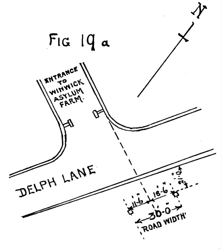 Fig.19a |
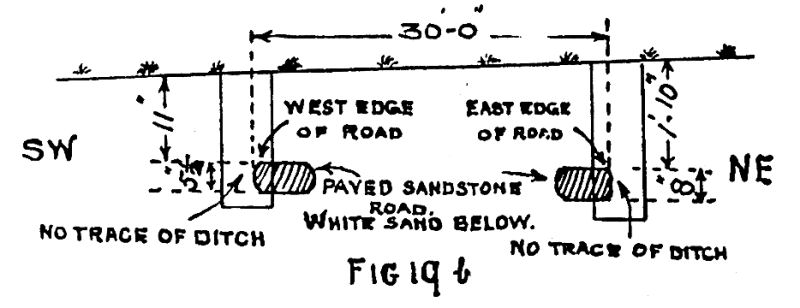 Fig.19b |
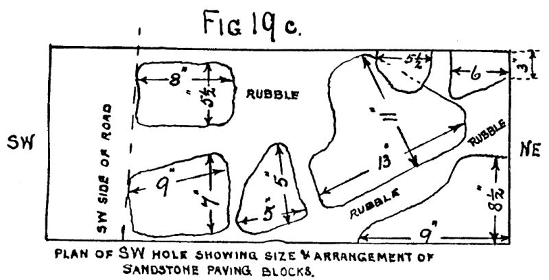 Fig.19c |
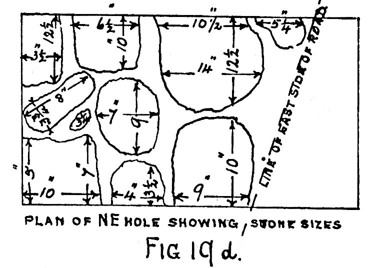 Fig.19d |
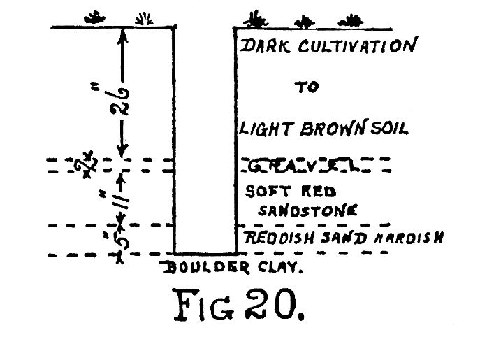 Fig.20 |
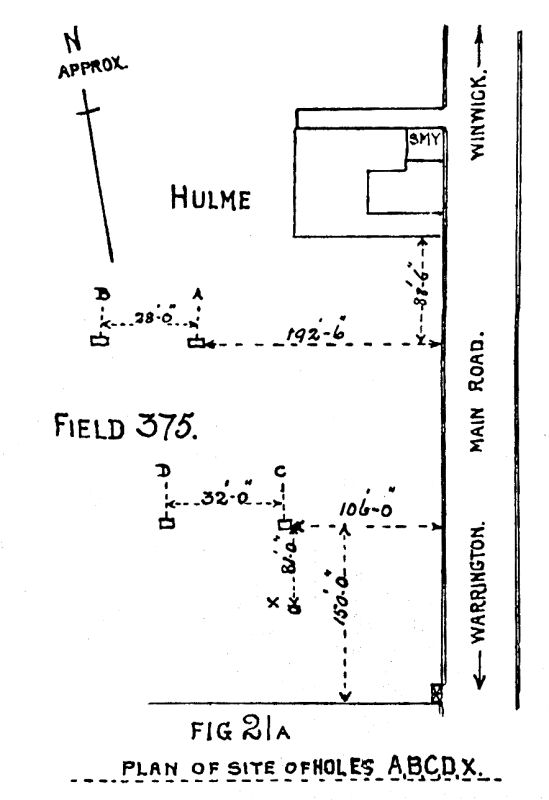 Fig.21a |
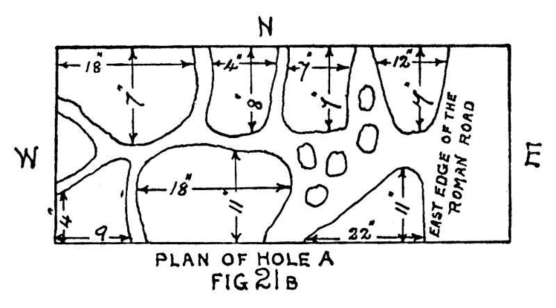 Fig.21b |
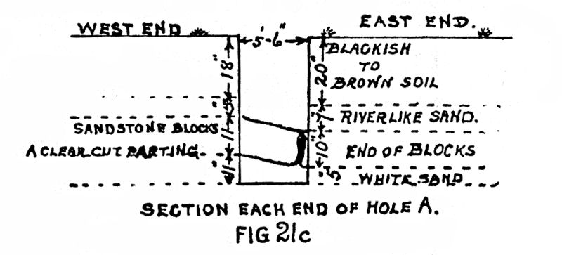 Fig.21c |
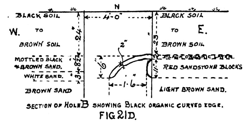 Fig.21d |
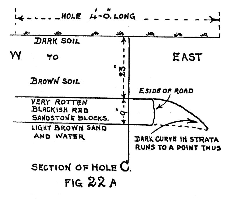 Fig.22a |
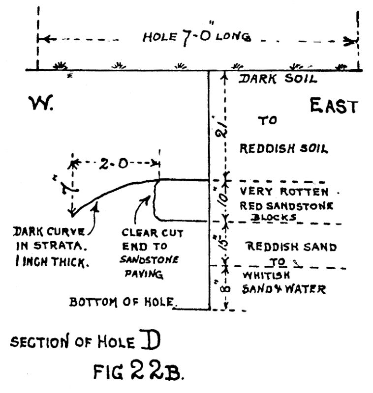 Fig.22b |
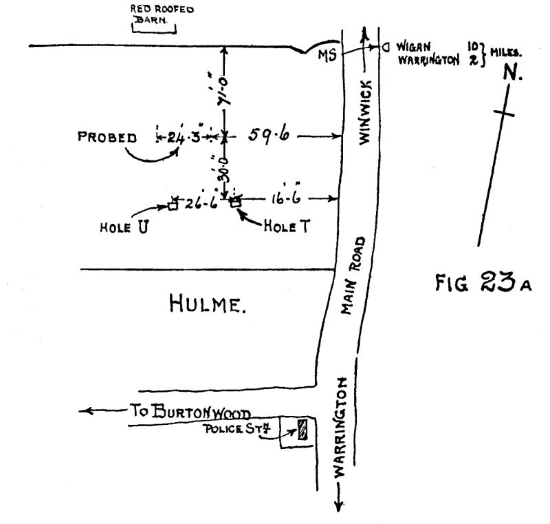 Fig.23a |
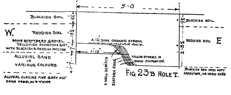 Fig.23b |
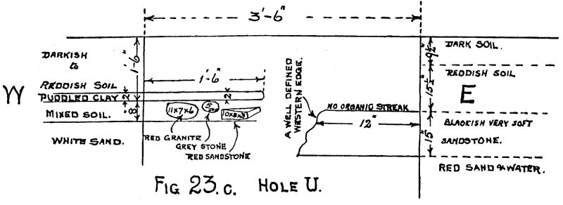 Fig.23c |
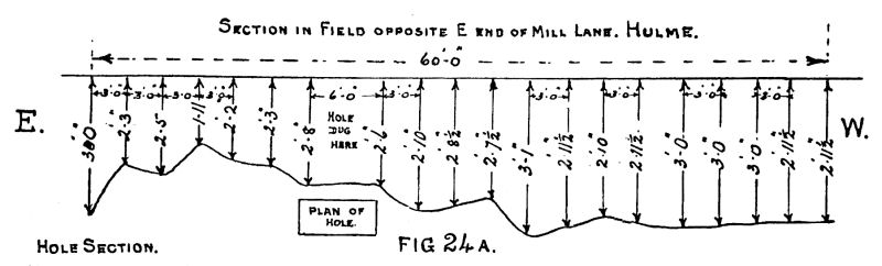 Fig.24a |
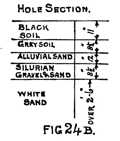 Fig.24b |
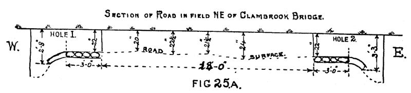 Fig.25a |
 Fig.25b |
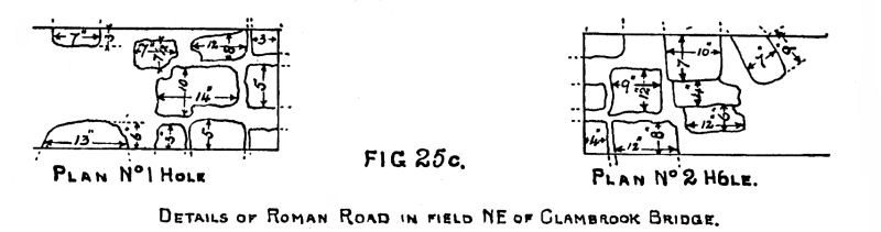 Fig.25c |
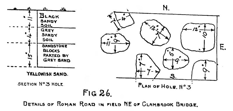 Fig.26 |
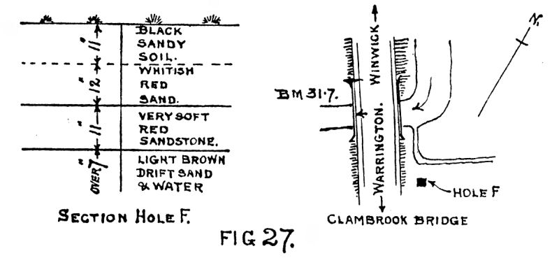 Fig.27 |
We were unable to do any actual work in the ground of the Winwick Mental Hospital. Enquiries failed to disclose that any trace of the Roman Road had ever been seen or heard of as passing through the grounds.
After a prolonged search, the Road was picked up again in field 153 south of Delph Lane (see Map, Fig. I), just opposite to the entrance to Delph Farm from Delph Lane. Both the Delph Lane and Farm entrance are about 10 feet below field level. A site plan, together with sections through holes dug at the east and also west sides of the road, and plans showing size and distribution of the sandstone blocks, are drawn on Fig. 19. The position of the Roman Road can be located in field 153 by taking the face of the north-east wall of the entrance road to the Delph Farm and prolonging it south-east into field 153. At 21 feet south-east of the Delph Lane south-easterly fence, the sides of Roman Road were 11 feet 6 inches to the south of the prolonged line and 18 feet 6 inches to the north of the line.
Two holes were dug, on the south and north edges of the 3o-foot-wide Road. The soil from the surface downwards contained plenty of Silurian gravel, which was also found embedded between the sandstone blocks in places. The stone was mostly red and hard, but some was yellowish and a little softer. Dark gritty soil seemed to be the binder. In some places, such as on the 13″ x 11″ block, a thinner piece of sandstone had been placed on a low-lying end to make up to proper height. Sandstone rubble had been used to make the surface level, gravel being put on top of that. The plough had disturbed and dispersed most of the gravel. Between the two holes the probe confirmed sandstone blocks. Outside the two edges of the Road, the ground was soft and sandy (white).
Another hole was dug 50 feet north of the southern hedge of field 153 at 192 feet 6 inches north-east of the hedge south-west of the pond which is in the south corner of the field (see Map, Fig. I). The ground here is softer than that to the north and north-west, consequently the sandstone blocks of the pavement were considerably decomposed and their outlines indistinct. They were covered by a 2-inch layer of fairly compact Silurian and quartz gravel. For section, see Fig. 20.
The Road was next discovered in field 375, Hulme Smithy being in its north-east corner (Map, Fig. 1). Measuring south 88 feet 6 inches from Hulme Smithy most southerly hedge and then measuring 192 feet 6 inches at right angles westwards from the main road from the Road fence, hole A was dug and the east edge of the Road found in it. The probe gave sandstone to the west for 28 feet, where hole B was dug and the west edge of the Road found, also the downwards curve of a 2-inch black, organic-like streak ; this did not appear at the east edge of the road. The sandstone blocks were soft enough for the spade to cut easily. Odd pieces were harder and could be removed in lumps. Spaces between blocks were filled in with whitish sand. Gravel seemed to be absent. A plan of the site, also one of stone sizes, and also of sections, is given in Fig. 21. The parting at the bottom of the sandstone blocks was very clear cut.
Two more holes, C and D, were dug 106 feet west of the main road hedge at 150 feet north of the south hedge of field 375. The Roman Road edge was found in each hole, together with a clear-cut curve which appeared as a dark line about 1 inch thick, as per sketch Fig. 22. The patterns of the very soft sandstone blocks were too indistinct for a close measurement to be taken, but they appeared to be 10-inch to 12-inch centres apart, block to block. Eighty-one feet south of hole C the probe gave sandstone at 1 foot 9 inches down. A piece of black Roman pottery was picked up by us on the surface of this field, No. 375, about 42 yards north of the south fence and 27 yards east of the west fence.
In the third field south of field 375 at Hulme, marked on Map, Fig. 1, with MS (Wigan 10, Warrington 2), the. probe gave ” sandstone.” Two holes were dug and the east and west edge of the Road were disclosed as per sketch (Fig. 23). The sandstone in the Road portion in plan had various colours of red, black and grey, however many thicknesses were sliced off with the spade, but they were of too indefinite character to draw. The sandstone had a well-defined parting from the strata beneath. Gravel was fairly plentiful in the 6 inches above the paving. The east and west edges of the Road had a clear-cut ending. In hole U, at the west end of it, there appeared -the remains of a puddled clay layer 2 inches thick, with mixed soil below, in which were embedded stones of very differing character. We were unable to come to any definite conclusion regarding this formation—it looked old, but not nearly so old as the Road.
Having now obtained a good general line of the Road running south, we followed it. In the field just east of the Winwick-Warrington main road, opposite the east end of Mill Lane, or Burtonwood Road, we dug a hole 22 yards east of the main road, and 24 yards south of the north fence to the field. At 311/2 inches down we found gravel 81/2 inches thick. We then probed carefully east and west and obtained gravel at the depths shown on Fig. 24, which also gives hole section. No sandstone was found, only gravel. See also Map, Fig. 1. At the Toll Bar Farm, Hulme, just south of the previously mentioned field we found hard gritty bottom 15 feet west of the south-west corner of the Barn by probing, and also at 27 feet west of the Barn corner. As the above is on the proved line of the Road it is included. It was not expedient to try and dig in that part of the farm.
In the field north-east of Clambrook Bridge on the Warrington Road we dug a hole 98 yards to the north of the centre of the bridge arch, and at 24 yards east from the main road ditch (No. 1 Hole, Fig. 25) ; finding in it, the west edge of the Roman Road, together with 2 curved organic bands about 3/8 inch thick, which started level with the top side of the most westerly stones, and also from the underside of the stones, and then curved downwards. The sketch also shows size and arrangements of the sandstone blocks. The probe then defining the breadth of the Road, another hole (No. 2, Fig. 25) was dug astride of the eastern edge of the road and the well-defined edge was found, together with two similar curved organic bands 3/8 inch thick. Hole section and plan of arrangement of sandstone is given in Fig. 25. A line of probings was taken at 3-foot intervals across the 24 feet separating the proved edges, and a profile obtained as shown on Fig. 25. It was noted that in the western end of No. I hole a few gravel pebbles occurred, 3 inches and under in size, mixed with the grey sandy band. In other parts of the holes very few pebbles were seen.
In the same field (north-east of Clambrook Bridge) a hole dug 19 yards east of the main road ditch at 35 yards north of the centre of the bridge arch disclosed the paving of the Roman Road as on Section and plan, Fig. 26. The sandstone blocks in this hole were decomposed to a depth of 1 inch externally. The lines of demarkation between the blocks were easily traced by following down the lines of partings of white sand. The sandstone is the ordinary red kind, of which there is a large local outcrop at Winwick. The ground where this hole was dug is extremely wet during the winter months.
The general line of the Roman Road traced so far pointed to it having passed close to or partly over the ground occupied by Clambrook Bridge. To check this, a hole was dug in north-west corner of the field to the south of the ditch on the east side of the main road just south of Clambrook Bridge, and rotten sandstone was found 23 inches down, 11 inches in thickness ; below this was light brown drift sand and water. On the sandstone were occasional 3-inch pebbles of Silurian gravel (see Fig. 27). This ground is very swampy indeed, so much so, that we had a difficulty in obtaining the correct thickness of the sandstone owing to water. No well-defined partings in the sandstone could be distinguished in plan. In the whitish red sand several pieces of wood about 1 inch thick were found, quite waterlogged, almost rotted away, but just hard enough to retain their shape and grain structure. This hole shows that the Roman Road passed just to the east of Clambrook Bridge (see Map, Fig. I). As we have now got to the bottom of the Map (Fig. 1), it seems to be an appropriate place to stop for a few moments and review the results obtained from the area covered by Phase II.
1. In Figs. 21, 22 and 25, a black, organic-looking layer, curving downwards, is to be noticed, being a continuation of the upper surface of the paved sandstone blocks. In Fig. 25 there is also a second downwards curve, being a continuation of the lower surface of the sandstone blocks. If this curve had been part of a ditch on either side of the Road, it would be reasonable to expect a complete profile of the shape of the ditch marked by the organic layer. Although careful search was made, we were unable to trace any signs of the curve extending farther than shown on Figs. 21, 22 and 25.
Another idea presents itself which is worthy of consideration. If the Road in Figs. 21 and 22 had been constructed by first taking off the top sod and the sandstone blocks then placed in position, some part of them would have been above the sod and some part below. In course of time sandy matter could have been blown or washed to either side and so made up the height level with the top of the Road. Vegetation would then get a hold. Over a period of seasons a layer of sandy humus would accumulate. When the Road ceased to be used, the gradual sinking of the Road by earthworms (see Darwin on Earthworms) and blowing of sand, etc., would cover it up and the curved humus layer would be preserved. The double lines of “black organic partings” in Fig. 25B suggest work having been done at two different periods. Another suggestion is that the Road had been constructed slightly higher (a slight embankment made), above the natural surface, at the time of construction, by placing the sandstone blocks directly on the sod.
2. No traces of tool-marks of any kind were noticed on any of the sandstone blocks. It is suggested that the sandstone was split off its bed by wedges in the quarry in large pieces, which were afterwards broken into smaller pieces. Very rarely was a piece seen more than 18 inches long.
3. The change of direction always appeared to be through an angle and not a curve as is modern practice.
4. Gravel was not so plentiful with the exception of Fig. 24B, where there was not a particle of sandstone seen or felt by the probe.
5. With the exception of the sandstone found just south of Delph Farm entrance, all the sandstone found in the Road in Phase II was very badly perished indeed, and in several places great care had to be taken to be sure that what we found was a paved road, but the variation in texture, colour, presence of sandy partings between the very soft blocks, were distinctive enough and quite convincing. The association with gravel and the obvious use made of gravel, and graded gravel at times at that, was another clue. Although field 375 is on a 50-foot contour and the road drops in its progress south, all the subsoil as far south as Clambrook Bridge is very damp indeed. The fields north-east of the bridge are lower than the bridge itself and its Bench mark.
6. The only find of any account, extra to the Road itself, was a small piece of black Roman pottery in the south-west portion of field 375.
7. The Road described in Phase II varies between 24 feet and 32 feet wide, as shown on Figs. 19, 21, 23, and 25.
8. It is to be noticed that in Fig. 24 records of sandstone are completely absent. There is no doubt that the Roman Road must have been laid over the western portion of the ground shown on Fig. 24, so we deduce that the flat western 24 feet shown on the sketch must have been the road.
9. Although the Bench mark on Clambrook Bridge is shown as being 31.7, the 25-foot contour line on the Ordnance Map, Lancashire, Sheet CIX, SW., 6-inch, 1908 Edition, is shown to run from south-west to north-east under the Bridge, hence the waterlogged soil in this area.
In the town of Warrington in places where the contour lines are 25 feet 0.D., floods are not unknown when the River Mersey is in flood and heavy rain falls at the same time, locally. The water flowing under Clambrook Bridge has to travel via very sinuous coursed brooks before discharging into the River Mersey via Dallam Brook and Sankey Brook—hence the water backs up and land gets flooded.
PHASE III.
(Figs. 28 to 47 inclusive.)
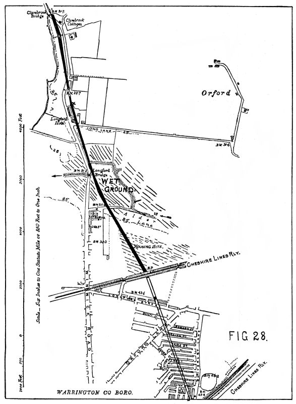 Fig.28 |
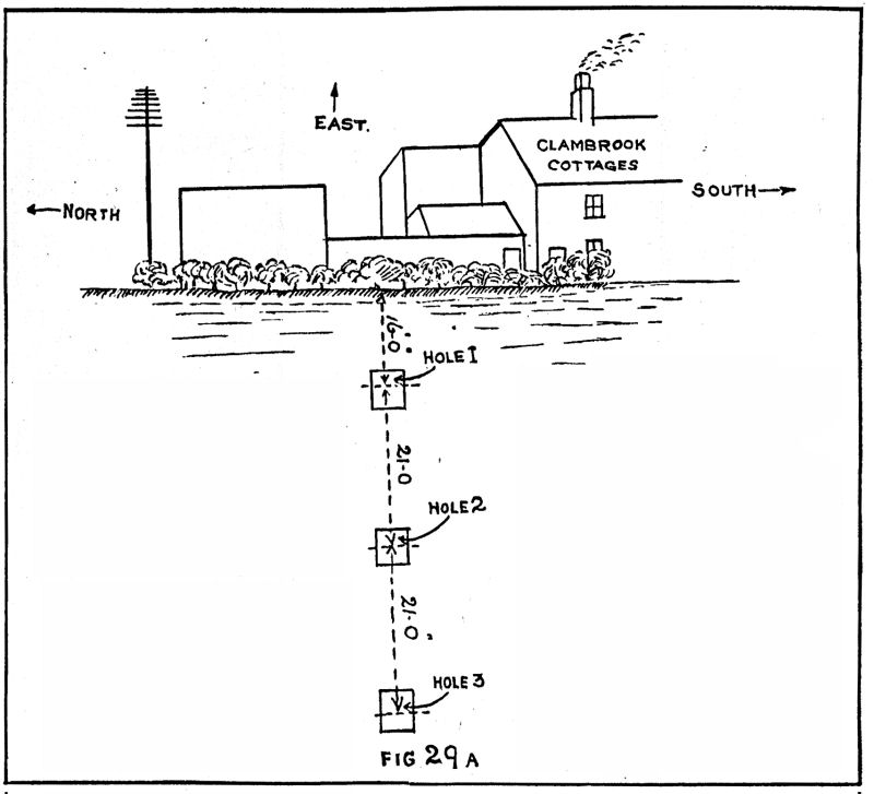 Fig.29a |
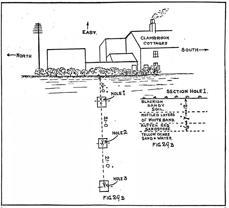 Fig.29b |
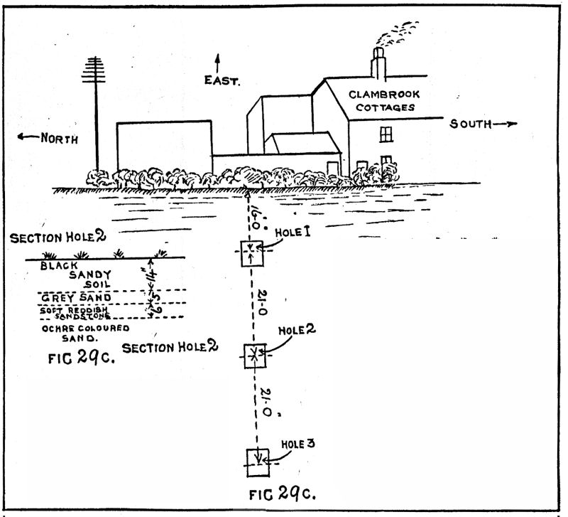 Fig.29c |
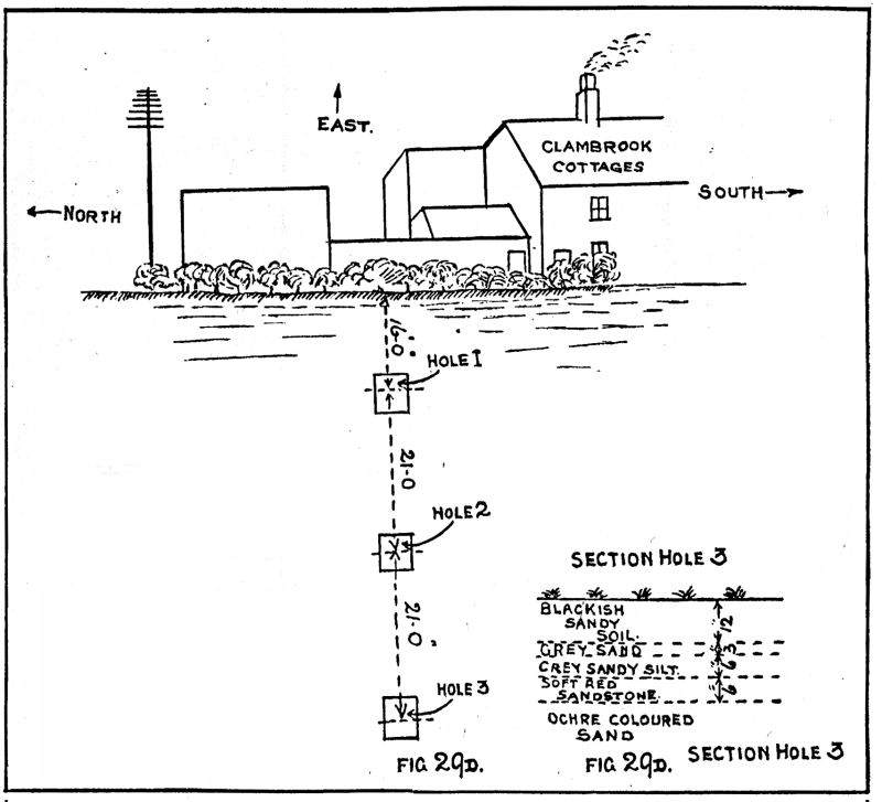 Fig.29d |
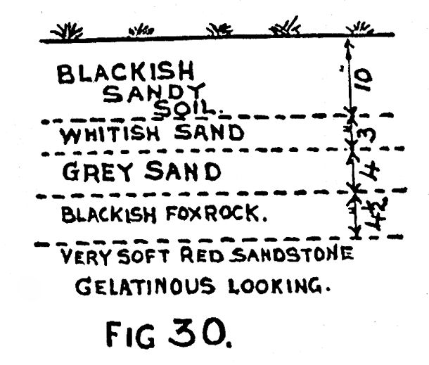 Fig.30 |
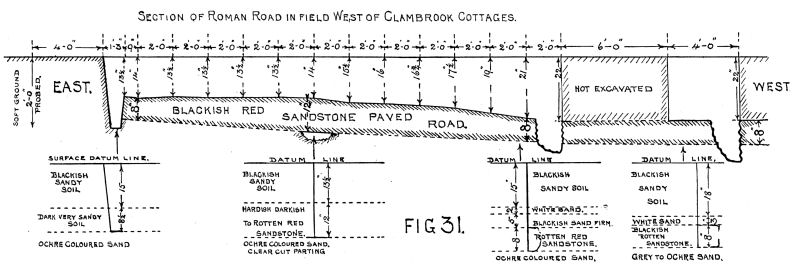 Fig.31 |
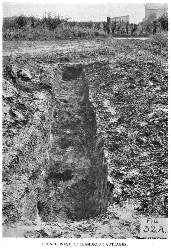 Fig.32a |
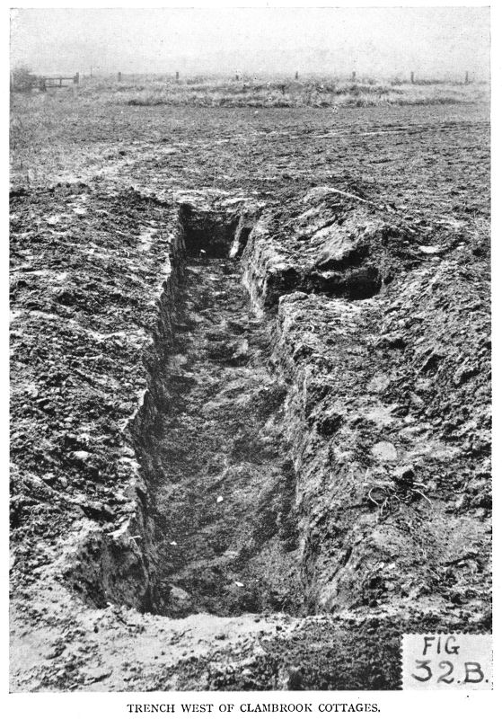 Fig.32b |
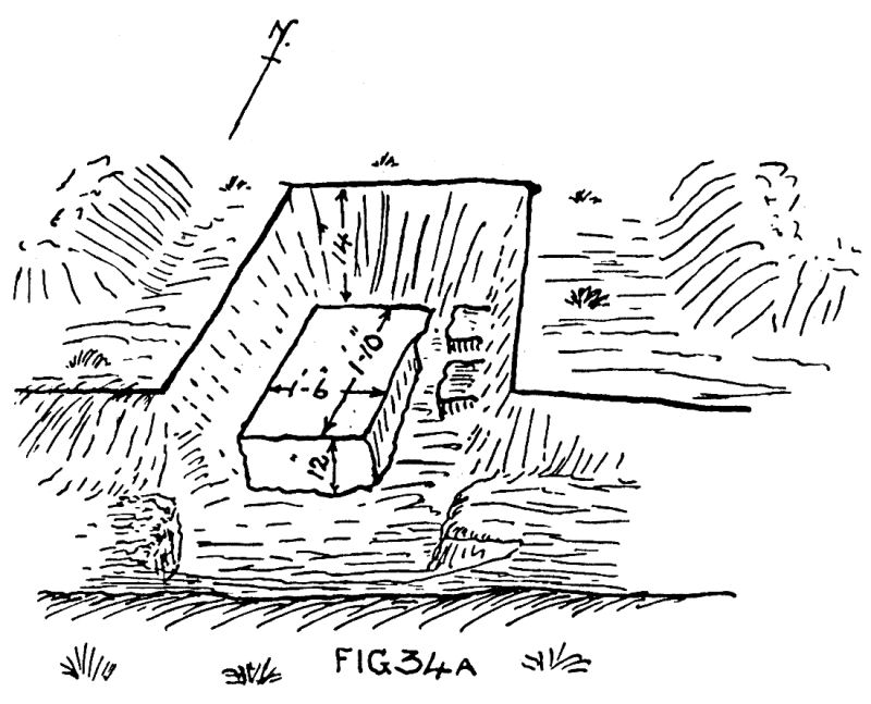 Fig.34a |
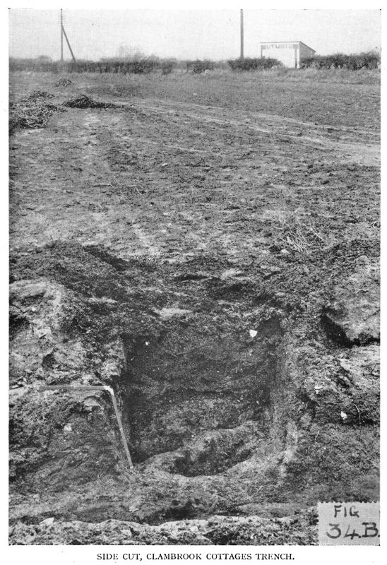 Fig.34b |
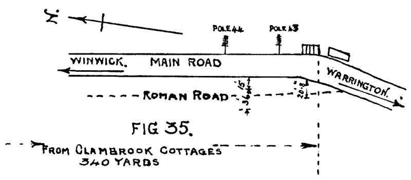 Fig.35 |
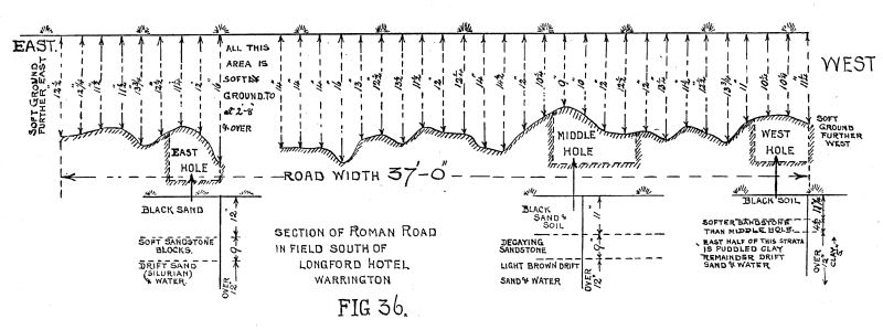 Fig.36 |
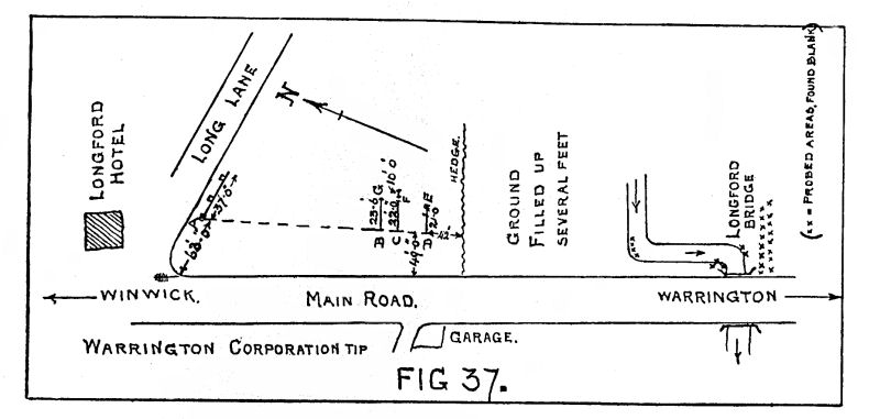 Fig.37 |
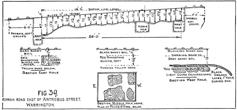 Fig.39 |
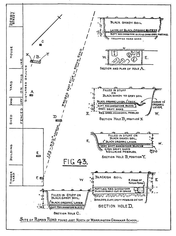 Fig.43 |
 Fig.47 |
See Map, Fig. 28, for Phase III from Clambrook Bridge to the field adjoining the south-east side of Warrington Parish Church (St. Elphins).
In the field just across the main road to the west of Clambrook Cottages, about 100 yards south of Clambrook Bridge, we dug three holes in line with the outbuilding to the north of the Cottages, as per Fig. 29, which gives plan of site and section of holes. (See also Map, Fig. 28.) Hole No. 1. The surface of the sandstone shows distinct evidence of being laid down in blocks and the spaces being marked by lines of lighter-coloured sandy material. The whole seems to have solidified into one mass, but the lighter-coloured sandy partings are much softer than the dark-coloured areas. The dark portions are roughly 12 inches across in irregularly shaped pieces, about 6 inches thick. There is ochre-coloured sand below which is just hard enough to be scraped away by a fingernail. Hole 2, similar. Hole 3, no evidence of light-coloured partings could be obtained. The east end of Hole I coincided with a line of marks put up where the probe at 20-yard intervals, working south, obtained evidence by feel of the existence of the east edge of the Roman Road which was corroborated by finding in another hole in the same field, the actual east edge of the Roman Road which will be described later. On looking north wards up this line from its south end, it cuts about I00 yards west of the large square tower of Winwick Mental Hospital, and on looking southwards from the No. 1 Hole, the line runs close by the east side of Longford Bridge (to be described later). No definite west edge of the Roman Road could be found as the sandstone layer was irregular on its western side. To the east of the line of marks, described above, the ground is soft so far as 2 feet 6 inches down.
Another hole dug 11 yards west of the main road fence and in line with the northern face of north house of Clambrook Cottages gave a section as drawn in Fig. 3o. Note the quality of the sandstone. The lower, very rotten, is the Roman Road, not the blackish ” foxrock,” as it is called locally.
In the same field, i.e. west of Clambrook Cottages, we dug a trench 5 yards to the north of the southern hedge and parallel to it—the eastern end being 15 yards west of the field gate on to the main road. Sandstone block paved road surface was found extending 34 feet 9 inches towards the west and farther. For the first 3 yards from the east end the sandstone blocks were much harder than those more to the west. The surface of the Road had well-defined lines of separation between blocks composed of dark grey sand much softer and lighter-coloured than the dark-red sandstone blocks. After the first 3 yards the Road surface had many smallish ” puddle holes ” 3 inches to 6 inches diameter, and of varying depths, some 6 inches deep, separating the sandstone blocks. These holes were filled with mud or silt. The layer of white sand shown on the sections (Fig. 32B) only existed from the west end of the trench to about the middle of the trench length. The parting lines between blocks were very similar to those exposed in the holes (Figs. 29B and 29c). A cross-section of the Road is shown in Fig. 31, together with four sections of the Road from different places.
A line was stretched tightly from east to west of the trench, and supported to keep it straight. At 10 feet west from the east end the ground rose 21/2 inches above the Datum line. The surface of the Road was measured, down from the Datum line at 24-inch intervals from the east end. We were under the impression that serious flood or floods had submerged the Road at this site sometime after the Road had ceased to be used. Note the layer of white sand only extending to about the middle of the trench from the west end, and the filling of all the ” puddle holes ” with mud or silt, except those in the easterly 9 feet of trench. It will be noticed that the photographs (Figs. 32A and 32B) only show 24 feet 9 inches of road exposed ; another hole was dug 6 feet farther west, as shown on the Road section drawing (Fig. 31). Some sand out of the parting between sandstone blocks was examined microscopically. At a point 10 to 11 feet west of the east end of the trench and in the north side of the trench, a side-cut was made to expose the Road and a sandstone block was carefully measured and lifted. The yellowish sand beneath and the dark-red sandstone block division was most clear and marked. The stone measured 1′ 10″ x 1′ 6″ x12” thick, sides fairly square, as per sketch (Fig. 34A, also Photo, Fig. 34B).
Passing into the next field to the south, we were only allowed to probe, as the field was under clover. The probe disclosed sandstone 22 inches down, which is the same depth as the Road was found in the next field to the north. The position was half-way between the two telegraph poles Nos. 44 and 43 ; No. 43 being the nearest pole to the north of the group of four cottages. Fifteen feet west of the west fence to the main road the eastern edge of the Roman Road was felt. The sandstone extended 36 feet farther west. Again, opposite the second cottage from the north of the four cottages as above, measuring westwards from the west fence of the main road, sandstone was found to extend 20 feet 8 inches westwards from the fence (see Fig. 35 and Map, Fig. 28).
It is evident the Roman Road now runs slightly to the east of south and under the present site of the Winwick-Warrington main road. Traces were probed for in the flooded land between Longford Hotel and where B.M. 29.7 is shown farther to the north of the Hotel (see Map, Fig. 28). Hard material was touched with probe and it was gritty, but water prevented investigation at point X, just north of the Hotel.
In the field to the south of Long Lane to the south of Longford Hotel on a line running east and west, 3 holes were dug, 11 yards south of Long Lane, the west hole being 20 yards east of the east fence of the Warrington Winwick main road. Sandstone was found by probe at depths from 9 inches to 16 inches down over a width of 37 feet. The line was afterwards probed at 1-foot intervals. The results and position of holes and sections are shown on Fig. 36. The partings of the sandstone blocks were lighter-coloured than the sandstone, but of practically the same hardness. The eastern half of the west hole had 5 inches of clay under the westerly stone edge. How far the clay extended eastwards we could not determine. The field was flooded to within a few yards of the three holes dug, so we had to be very quick in getting measurements in the holes, as water oozed in quickly.
A debated point as to where the Roman Road crossed the Longford Brook has not hitherto been satisfactorily settled in any literature to which we referred. At three points, as per plan on Fig. 37, we found the western edge of the Road by probing. Point A is the western edge of the Road shown on Fig. 36. Points B, C and D were found to be the western edge. At point D 49 feet east from the eastern boundary of the Warrington-Winwick main road the sandstone is found 2 feet 1 inch down ; at 50 feet it rises to 1 foot 111/2 inches down. Working eastwards for 21 feet, the east side of the Road was felt at point E, 2 feet 8 inches down. At C hard bottom was found at 1 foot 10 inches over a distance eastwards of 22 feet, when it stopped at 1 foot 81/2 inches down. At F, for the next 6 feet there was soft ground down 3 feet and farther. Then for 10 feet farther east hard bottom was felt again at 2 feet 3 inches, 2 feet 01/2 inch, and 1 foot 111/2 inches down. At B the western edge was1foot 111/2 inches down and extended eastwards 23 feet 6 inches, where it was i foot 11 inches down at G and at 1 foot farther east the east side was felt at 2 feet 3 inches. Points A, B, C and D were very nearly in a straight line and pointed south by east for the north-west houses of South Avenue, but misses Longford Bridge to the east. From D the compass bearing to A was 356° and to the south-west buttress of Longford Bridge 189°, and to the centre of the east wall of Longford Bridge 184°, and to the north-west corner of the garden forming the south end of the sight-line from South Avenue to Longford Bridge south-west corner, 174°. This last was a poor sight through a hedge. Compass variation, 17° W. The field farther to the south of the one in which the previous finds were located, has been filled up several feet.
We spent a long time trying to find traces of the Road about the stream which flows under Longford Bridge, but could not obtain the slightest clue.
In the open ground east of Antrobus Street, at a point about 1,000 feet south by east from Longford Bridge, the Roman Road was found again as per plan (Fig. 28). Three holes were dug and the two sides of the Road were found. In the west hole the curved black organic layer was again found, 1 inch thick. The east hole flooded badly ; we were unable.to see any curved organic layer if it existed, owing to muddy water ; even measurements were difficult to get accurately. The ground was probed from east to west every 12 inches to hard bottom. The field sloped down from west to east 11 inches in 18 feet. Fig. 39 gives the depths the sandstone Road was found from the surface, also sections of the three holes and a plan showing sizes of stones found in the middle hole. The partings between the sandstone blocks are of black sandy material. Note should be taken of the clear-cut end of the sandstone paving in the west hole, together with the black organic curved layer 1 inch thick, which was also found to be on top of the sandstone paving. The west edge of the Road was found by probe in eight places over a length northwards of about I00 yards, and a compass bearing taken along the average. This gave 352° var. 17° W. and cuts the north end of the Corporation Tip wall just west of the Longford Hotel. A slight bend in the Road is apparent at this point—more to the south-east than south by east.
The heavy, line-shaded area on Fig. 28 shows approximately the very wet and often fl00ded ground. No trace of the Road could be found along the sides of Alder Lane by probing or digging. The drainage from the filled-in area to the north-west may possibly have caused the sandstone to perish.
To obtain a good line, we located the Road to the west of the two north-westerly houses in South Avenue, which are practically on a line in prolongation eastwards of Moss Street. Dug two holes in the garden and found the east edge of the Road in both, also found the curved black organic layer in each. The west edge of the Road was found by probing 21 feet 6 inches west of the garden fence. The point was obtained where the west edge of the Road passed under the garden fence. Road 18 feet wide. Plan of site and hole S.A., with section, is shown on Fig. 40. Water prevented a pattern of the paving being obtained.
In West Avenue, Orford, the probe gave sandstone over a width of 29 feet. The east side was 4 feet west of the west fence to the passage between Nos. 31 and 33. Soft ground was felt as far down as 3 feet beyond the east and west sides of the 29-foot area. At 16 feet west from the east end, the hole A was dug, which gave a section shown on Fig. 41. The centre of this 29-footwide road is about 120 yards east of the centre of the railway bridge at the west end of West Avenue, where it meets South Avenue. On probing in the passage between the gardens at the backs of Nos. 33 and 35 and the C.L.C. Railway, sandstone was found over a space of 41 feet 9 inches. Hole B was dug, which gave a section shown on Fig. 41. The plan of site and sections are all shown on Fig. 41, which shows the location in relation to the signal post shown on Map, Fig. 28, as S.P.
To the south of the C.L.C. Railway the ground is very disturbed, having had a lot of sand excavated in the 1890-1900 period. Intense probing failed to disclose anything about the centre part, i.e. half-way between the C.L.C. Railway and Longford Street. At a few inches from the south fence of the C.L.C. Railway and 9 yards west of the signal post the probe gave signs of sandstone at 1 foot 8 inches down over a width westwards of 24 feet. Three years afterwards a hole was dug at this spot and a peculiar reddish iron-oxide-like layer was found with whitish sand below. No pattern could be distinguished to show if it had been laid down as blocks or was only a precipitation of water-soluble iron in the white sand lower down. The line, however, coincided with the sandstone paving found to the north of the railway (see Fig. 42).
On probing in the opening just west of No. 16o Longford Street, sandstone was again found over a width of 26 feet, roughly 2 feet 8 inches down. A plan of the site and section of a hole dug is given on Fig. 42. No signs of gravel were seen. It is evident a change in direction of the Road slightly westerly took place about where the centre of the railway now is.
The next open space we could find on the compass-bearing of the Road southwards was north of the Warrington Grammar School playground, and just east of Derby Street and west of “Sixpenny Walk.” For details of plan and sections of holes dug, see Fig. 43. Hole A was of the nature of a trial hole. Top soil, black, sandy, poor, 15 inches thick, then 6 inches of soft red sandstone: a plan is shown giving block sizes and shapes and lines of partings. The ground between hole A and the fence to the Yard is very disturbed. The compass bearing of where the Road should run obviously showed that the western edge of the road was farther west than hole A. As the ground was disturbed to the west of A, probably the western edge would be found by moving north. The probe gave a clue and hole B was dug and the western edge of the Road was found in it, together with the black organic layer on the top of it, i inch thick, together with a very well-defined curve in it farther west than the edge of the Road. The section of hole B at position X is given, as is also a section of position Y in hole B also. Hole C was dug to corroborate. The black organic layer was found on top of the sandstone, but we were a little too far to the east for the western edge to be uncovered. The probe gave signs of the eastern edge of the Road and hole D exposed it. But no organic layer was seen in it. Hole F, west end, gave soft yellowish sandstone 9 inches thick, which was mottled with red, but at the east end the sandstone was 1 foot 11 inches down and 1 foot 3 inches thick ; no partings could be seen in slicing the soft sandstone horizontally, but could be distinguished when cutting vertically. In hole E the curved organic layer showing the eastern edge of the Road was very pronounced, brown soil on the top of it, and white to grey sand below it. The subsoil under this area is boulder clay, but is very uneven in its surface : for instance, in hole D it was found 3 feet 3 inches down, with drift pebbles on top ; in hole B at 3 feet 6 inches down there was hardish red sand with Silurian pebbles on it, under grey sand. The dotted lines show direction of the sides of the Roman Road exposed in the various holes, 46 feet wide.
In the book, Boteler Grammar School, 1526-1926, p. 29, there appears the following :
“Rev. Edward Owen, 1757-1807: ‘ Found the school in a dilapidated condition, the building in ruins, the roof ready to fall in, and the floors and walls all clay. He at once put it in a thorough state of repair. . . . He also stopped up the Roman Road which ran by the School, from Latchford to Winwick, and built his stables upon it.’ ”
We proceeded to investigate this. In School Brow (the name of a street) there are the following: a dwelling-house, No. 96, built up against the west wall of the Grammar School Gardens. No. 94 adjoins No. 96, farther west, then comes an open space and then a cartway leading to the stables and ground belonging to Nos. 96 and 94. West of the cartway is an old detached house. In the Ropery Yard, behind the detached house, we dug hole M, and in it found the west edge of the Roman Road. Behind No. 94 we dug hole N and found sandstone blocks, but by probing in some fowl runs there, we found the line of the east edge of the Road and made it out to be about 46 feet wide, similar to that described and shown in Fig. 43. The plan of this site, holes dug and sections and plans of holes, are shown in Fig. 44. The west edge of the Road was very well defined in the westerly hole.
It is evident that a change of direction in the line of the Road occurs just south of the area shown on Fig. 43. The east edge in Fig. 43 runs 169° and 349° magnetic, whereas in Fig. 44 it runs 142° and 322°, i.e. 27° more south-easterly (compass variation about 17° W.). The line dotted and marked ” 322°. East side of Road probed,” intersected hole E on Fig. 43.
If the stable shown in Fig. 44 is the stable (and it seems a very old building) built by the Rev. Edward Owen, it is, without any doubt, built upon the Roman Road.
The next open space on the compass line southwards, which we could find, was about the south-eastern corner of the Warrington Parish Church churchyard. The Rev. Canon Willis very willingly allowed us to probe his Rectory garden and the field south-east of the Parish Church. Eventually a hole was dug and the paved sandstone Road was found 2 feet 5 inches below ground, made of sandstone blocks 7 inches thick. The well-defined eastern edge of the Road was exposed. A series of probings found the eastern edge of the Road west by north and south by east of the edge found in the hole. The average line of the probings gave, when the 6-inch map was properly set on the ground, a line running straight for the eastern edge of the road found just to the west of the Warrington Grammar School. No organic layer was to be seen, but occasional pieces of gravel were found embedded in the sandy partings between the sandstone blocks. Two weeks later the site was revisited and two more holes were dug about 25 feet farther south —one in the field and one in the Rectory garden. In the field very soft sandstone was found, so soft that it could easily have been overlooked as being unimportant ; some spots were harder than others and much redder in colour. The general shade was as if prolonged or constant wetting had leached away most of the binding and colouring matter out of the stone. The top of the layer was not very clearly defined as it bordered on the sandy red soil, but in the 6 inches above the sandstone and well mixed with the red sandy soil, a good many gravelly pebbles were found. The dividing-line between the underside of the sandstone road and the underlying grey alluvial sand was very marked. The writer knows very well indeed from personal observation that this area has been flooded several times most winters for over the last fifty years.
The western edge of the Road was found in the Rectory garden 2 feet 1 inch down and was 7 inches thick, whereas in the eastern hole the sandstone was 18 inches thick. We were unable to distinguish the shape or size of the blocks as they had lost most of their colour and were very soft indeed, but the west edge was definite. Occasional pebbles were found in the 6 inches immediately above the sandstone Road. A plan of the site, together with sections, is given in Fig. 45.
At the south-eastern side of the field there runs a ditch, and beyond this the ground has been filled up, a street made (Farrell Street) and houses built. Although careful watch was kept on a cable trench dug 3 feet deep from the Electricity Works in Parr Street, passing Howley Quay, to the north side of the new bridge over the River Mersey at Manor Lock, we were unable to distinguish any signs of the Road in the excavations. Fig. 46 shows a continuation of the course of the Road south, from the south end shown on Fig. 28. We were unable to find anything definite farther south of the Rectory of any evidence of the course the Road took, in spite of much searching, by probing and digging, examining maps and documents, and cross-questioning ” oldest inhabitants,” etc. A description of ground tested will be given later on in the hope that definite nil results may be useful to others in the future as well as perhaps being of interest as to the steps taken to try and obtain definite evidence as to where the Road crossed the River Mersey and the direction taken after crossing.
As we had got to the farthest point south to where we could definitely say we had obtained clear evidence of the existence and position of the Roman Road, it may be the proper place to review Phase III, Clam-brook Bridge to the Warrington Parish Church (St. Elphin’s).
I. The Road changes direction five times in Phase III. The reason for three changes to the south of Clambrook Bridge is obviously on account of the wet marshy ground to the west of Clambrook Cottages and Longford Hotel and to the east of Longford Bridge. The 25-foot contour line juts south to the north-west of Longford Bridge and the 25-foot line just south of the Bridge tends to move northwards. At this place there is the narrowest patch of really low ground, and swampy flooded land at that in winter, to be crossed.
2. The subsoil is very wet in all places where holes were dug, covered by Phase III. The sandstone blocks are very badly perished in by far the majority of holes, so much so that in places it was difficult to make out the sizes of the stone blocks. Often the perished stone could easily be cut with a spade.
3. Very little gravel was seen in situ on top of the sandstone foundation.
4. No other stone but sandstone was seen to have been used in the foundation.
5. The curved layer was disclosed to the west and east side of the Road in various places. In only one case did it take a ditch-like curve.
6. The change of direction to the north of the Grammar School suggests a desire to get to high ground as soon as possible after crossing the River Mersey.
7. The narrowing of the Road as it approaches Longford Brook from Long Lane seems to suggest an approach to a ford or bridge over a stream east of the position where Longford Bridge now is.
8. The changes in direction on the north and south sides of Longford Bridge in each case within 500 yards of the present Bridge suggests very careful investigation of the area before the final lay-out of the Road at this crossing.
9. We did not find any Roman artifacts in the area covered by Phase III except the Road.
A move was now made to the Cheshire side of the River Mersey opposite to Howley Quay on a prolongation of the line of the Road from the Grammar School to the Parish Church (consult Map, Fig. 46). Opposite Howley Quay is a landing-stage. We probed 3 feet deep along the dotted lines between I . . . 2 . . . 3, also along dotted lines about 4 . . . 5 and also 6 ; no trace of the Road. There appeared to be a hard layer between 2 and 3, but on digging down we could not construe the hard layer into being remains of the Roman Road.
“Rumour” has it that the Road formerly went past some houses at the east corner of ” Pumping Station ” marked ^, 27.0 on the Map. The pumping station works area during the excavations were often visited. We interested the Clerk of Works and also the Contractor. The only finds during the excavation were pieces of Elizabethan pottery in the top 3 feet ; below that seemed to be virgin alluvial deposits.
The dotted lines about 7 were probed 3 feet deep without result. At 8 two trenches were dug down to 5 feet 3 inches. In one, some medieval pottery, coal and odd pieces of sandstone were found about 4 feet down, but below that was alluvial silt. In the eastern one, dug 27 feet long by 4 feet deep, as per sketch and sections, a very mixed section was found, but nothing which could be construed into the Road.
At the south-west end of “The Weir” on the Island, at 9 . . . , there was found a very short piece of paving of sandstone which looked like a road sloping downwards from north-west to south-east. As there used to be a boat-repairing establishment and a dwelling-house about this spot about 1880, which the writer remembers, it was considered to be perhaps remains of the establishment. Tradition has it that when the old bed of the River Mersey ran eastwards across Victoria Park, then curved southwards near Manor Tannery and then ran westwards along the south side of Victoria Park, there was a ford used by the Romans about the M in MANOR TANNERY, SO 10 . . . II . . . 12 . . . lines were probed 3 feet deep without touching anything hardish. The dotted lines to the west, south and east of 13 . . . by Manor Tannery were now probed 3 feet deep ; without result. The gardens back and front of No. 17 Hawthorne Avenue, about 500 feet south-west of Black Bear Bridge over the Latchford Canal shown as 14 . . . on Map, Fig. 46, were also probed 3 feet deep to clear up a hint given, without result. A new sewer is being made (November, 1933) at the time of writing, and has been under close observation from the east side of Latchford Grange, through 13 along Wash Lane to opposite Christ Church Vicarage, where it turned westwards up the narrow lane which gradually curves from west to southwest and then south, and thence under the railway bridge to about Although this sewer has been dug about 9 feet deep, no trace of the Road has been seen. A sewer has also been laid along Loushers Lane, from where it crosses the Latchford Canal to where Loushers Lane joins the southern end of Wash Lane to the south of the L.M. & S. Railway ; sewer depth about 7 feet, no signs of the Road anywhere. A considerable number of new houses have been built in the area north of Loushers Lane from about the h eastwards, also to the south of the word Lane. Although a careful watch was kept on drain excavations and foundation holes, no signs of the Road were seen.
A new School has recently (1932-33) been built just south of Black Bear Bridge and in the foundations holes and trial holes about 15 no trace of the Road could be seen.
The Roman Station at Wilderspool is 150 yards west by south of Victoria House in the south-west corner of Fig. 46, Map.
The following statement made to the writer is here placed on record:
Mr. W. A. Shaw, Foreman at Howley Quay, Warrington, of the Manchester Ship Canal Company, stated that the Roman Road, according to tradition, came from Farrell Street [the street to which we had traced the Roman Road] to Howley Quay. (See Map, Figs. 46 and 47.) In 1917, during the War, the foundations of the Howley Quay warehouse were giving way, having been built in 1761. While excavating for a concrete foundation, when about 10 feet deep, two oak posts were uncovered, one vertical and one leaning towards the -river. These posts were about 2 feet diameter and were quite black. They were so hard that no saws used by the joiners could cut them. These two posts had a very heavy iron chain fastened to them. The chain was made of about 5/8 inch diameter metal, oval links about 3 inches long. There was no evidence as to the use of these posts or chain. They were eventually concreted over, as they were unable to draw them out. Mr. Shaw is convinced that the chain and posts were used formerly in connection with the old Ferry. He remembers that his father and grandfather both spoke often about Howley Quay, and heard his grandmother say, ” Your grandfather will come home across the, Ferry,” meaning the Howley Quay Ferry, i.e. the Manchester Ship Canal Private Ferry.
The sketch (Fig. 47) shows the position of the posts as pointed out to the writer, on the site, by Mr. Shaw.
(Dictated to the writer by Mr. Shaw at Howley Quay, Warrington, on 21 November, 1931.)
BRERETON FAIRCLOUGH.
A full detailed report of this investigation, with sketches and photographs, has been presented to the Warrington Museum and Library Committee by the writer in memory of his gifted friend and fellow investigator, the late Mr. G. A. Dunlop, F.S.A., formerly curator of the Warrington Museum.
B. F.
(1)1836 Edition, Vol. III, pp. 575-80.
(2) Roman Lancashire, pp. 65-6.
Transcribed from original source, This version and images are ©2006 Steven Dowd.
Thank you to Siobhan Burgess for the help checking and formatting my transcription efforts.