Haydock Historic Characterisation project from 2011 conducted by National Museums Liverpool and English Heritage
| Township: |
Haydock |
| Geology: | The solid geology is coal measures sandstone overlain by drift deposits of boulder clay. |
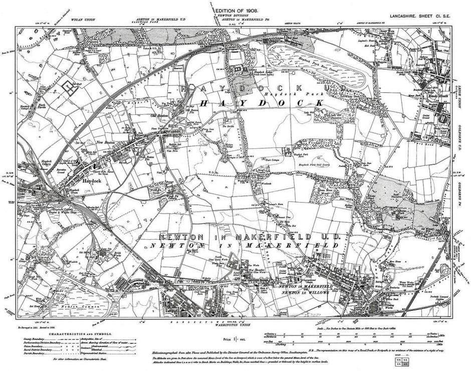
| Historic Core: | According to the OS 6 1st Edition map, the main historic core of Haydock appears to have been based at Haydock Town and Old Boston. Linear settlement development also exisits between Haydock Green and Old Boston. Haydock Green is named and depicted on Greenwood(1818) and Hennet (1830) maps. Only the township of Haydock is named on Hennet map (1830) but continues to show the historic core. |
| Origin of Name: | Hedoc (1169). Place where barley is grown (1; 2). From the Welsh Heiddiog (2). Heddoch (1170), Haidoc (1212) and Heydock (1508) (2). |
| Topography: | Lies on relatively low-lying ground that gradually rises northwards. |
| History: | Originally part of the parish of Wigan, the manor of Haydock was granted to Orm de Haydock in 1168. The manor was passed down and held in two portions between Hugh and William Haydock in 1212. By 1461 the land had passed to the Duke of Exeter and was therefore in the possession of the Crown. By the fifteenth century, the de Haydocks land had passed to the Leghs of Lyme who kept hold until the nineteenth century. (3) |
| Present Landmarks: | Present landmarks outside the historic core include: Sankey (St Helens) canal was constructed between 1755-57 and was Britains first industrial canal. It was abandoned during the mid twentieth century. (4) |
| Haydock Park and Racecourse had its inaugural National Hunt meeting in 1899. During World War II the racecourse was used for storage by the USAAF, who were associated with the RAF base at Burtonwood. (4) | |
| Historic Landmarks: | The fifteenth century moated site, Peel Hall or the Pele of Haydock, lay just on the northern outer limits of the core and also belonged to the Legh family. The site was demolished and the field named Peel Hall meadow. The moat is not visible due to a building development. (4) |
Sir Peter Legh acquired Haydock Hall from the Duke of
Exeter in 1461. Previous to this, Hugh de Haydock supposedly lived there in the thirteenth century. The hall is located on the southern outer limits of the core. The manor house and moat were destroyed sometime before the mid-eighteenth century. (4)
Bruche Hall, a moated site south of Haydock Green, is
first known from the Legh survey of 1466. By 1602 the property was sold to Peter Legh of Lyme whose family held it until the late nineteenth century. The hall was demolished by 1896 and is now lies under five metres of spoil. The moat has been destroyed (5).
Haydock Lodge was thought to be of considerable
antiquity. It was at one time used as an army barracks and lunatic asylum. (4)
Early Activity:
Evidence for Prehistoric activity in the area is scarce. A perforated stone hammer represents the only discovery from this period in Haydock. Poor drainage and heavy soils would have probably discouraged early farming activities and settlement. (4; 6)
The only evidence surviving for the Roman period in
this area would be the Roman road running adjacent to Haydock Park linking Warrington to Preston, running through neighbouring Newton-le-Willows. (4; 6)
Significant Post-Med Activity: The rapid growth of Haydock was a result of the coal mining industry surrounding the town. Previous to this the area had been dominated by agricultural practices. Haydock colliery (now built over) and numerous other coal pits were located on the outer fringes. The success of such an industry relied, in part, on the Sankey Canal that provided access to coalfields in St Helens and saltworks in Cheshire and Liverpool. Haydock railway, now disused, and other wagon ways assisted in servicing the collieries. (4; 7)
| Maps: | Yates W. 1786 Map of Lancashire (LRO DR 179/5) |
| Greenwood 1818 West Derby Hundred (LRO DDPR 144/11). | |
| Hennet G. 1830 Map of Lancashire (LRO). | |
| Haydock Tithe Map 1839 (LRO DRL 1/34). | |
| 1st Edition OS 6 Lancashire Sheet 101, published 1849 (surveyed 1845-46). | |
| References: | (1) Mills D. 1976. The Place Names of Lancashire. Batsford. London. |
| (2) Eckwall E. 1922. The Place names of Lancashire. Chetham Society. Manchester. | |
| (3) Farrer W. and Brownbill J.A. 1911. The Victoria |
History of the County Of Lancaster. Volume Four. Archibald Constable & Company Limited. London.
- Merseyside Historic Environment Record documentation.
- Lewis, J. M. 2000. The Medieval Earthworks of the Hundred of West Derby: Tenurial Evidence and Physical Structure. British Archaeological Reports. British Series Volume 310. Oxford.
- Cowell R.W. and Philpott. R.A. 2000. Prehistoric,
Romano-British and Medieval Settlement in Lowland North West England. National Museums and Galleries on Merseyside. Liverpool.
- University of Manchester Archaeological Unit. 1996
An Archaeological Desk-based Assessment of Yew Tree Trading Estate, Haydock, Merseyside. University of Manchester Archaeological Unit. Manchester.